
- Selector Map
- Mediterranean Sea (All)
- Western Mediterranean
- Central Mediterranean
- Eastern Mediterranean
- Adriatic & Aegean Seas
- Strait of Gibraltar
- Balearic Islands
- Ligurian Sea
- Corsica and Sardinia
- Strait of Bonifacio
- Sicily and Malta
- Bermuda to West Indies
- South Florida
- Florida to West Indies
- Gulf of Mexico
- Caribbean Sea
- Virgin Islands to Dominica
- Leeward Islands
- Windward Islands
- Gulf of Honduras
- Approaches to Panama
- Northern Europe to Iceland
- British Isles
- S. Ireland to English Channel
- English Channel
- Bay of Biscay
- Portugal to Gibraltar
- Canary Islands
- Labrador Sea and Greenland
- Nova Scotia and Newfoundland
- New England
- Chesapeake and Delaware
- Cape Hatteras to Florida
- Newport to Bermuda
- Great Lakes
- Great Lakes (all)
- Lake Superior
- Lake Michigan and Lake Huron
- Lake Ontario and Lake Erie
- North Atlantic Ocean (All)
- Tropical Atlantic Ocean
- Northern Transatlantic
- Southern Transatlantic
- Mediterranean to Caribbean
- Azores to Mediterranean
- South Atlantic Ocean (All)
- Cape Town to Rio de Janeiro
- Buenos Aires to Rio de Janeiro
- Cape Horn - Drake Passage
- South Africa to Seychelles
- North Pacific Ocean (All)
- Gulf of Alaska
- California to Hawaii
- USA West Coast
- Strait of Juan de Fuca
- Southern California
- California to Mexico
- Baja California Peninsula
- Mexico to Panama
- Panama to the Galapagos
- North America to Polynesia
- Sea of Japan
- Japan to Micronesia
- Strait of Malacca
- South China Sea
- South Pacific Ocean (All)
- Fiji to the Marquesas
- NE Australia and Coral Sea
- SE Australia and Tasmania
- SW Australia
- New Zealand
- Southeast Pacific Ocean
- Northern Indian Ocean
- Southern Indian Ocean
- Red Sea and Arabian Sea
- Southwest Australia
- Giraglia Race
- Middle Sea Race
- Antigua to Bermuda Race
Atlantic Rally for Cruisers (ARC)
- Cape to Rio Race (South Atlantic Race)
- Charleston Bermuda Race
- Fastnet Race
- Marion to Bermuda Race
- Newport Bermuda Race
- Pineapple Cup (Montego Bay Race)
- Regata al Sol (Pensacola to Isla Mujeres)
- RORC Caribbean 600
RORC Transatlantic Race
- Transatlantic Race
- Bayview Mackinac Race
- Chicago Mackinac Race
- China Sea Race
- Corona del Mar to Cabo San Lucas Race
- Long Beach to Cabo San Lucas Race
- Newport Beach to Cabo San Lucas Race
- Pacific Cup
- Sydney Hobart Race
- Transpac Race
- Tropical Warnings
- World Pilot Charts
Rolex Middle Sea Race
Rolex Sydney Hobart Race

We offer custom Weather Routing and Historical Weather Services
If you use this site on a regular basis, please consider helping us out...
PassageWeather.com specialises in Sailing Weather Forecasts... We provide 7-day Wind and Wave Forecasts to help sailors with their passage planning and weather routing. Before and during deliveries, ocean races, regattas, cruises, and all other types of offshore passages, we have your whole route covered.
Our sailing weather forecasts are derived using data from the most trusted and reliable weather models available. These models include the GFS and WaveWatch III models, the same weather models that produce the GRIB files used by modern electronic navigation software and weather routing software.

We have a small favor to ask you.
More people are using PassageWeather than ever, but advertising revenues across the web are falling fast. And unlike many other websites, we haven't put up a paywall - we want to keep our website as open and free as we can. So you can see why we need to ask for your help.
PassageWeather's forecasts take a lot of time, money and hard work to produce. But we do it because we believe our forecasts matter.
If everyone who uses our weather forecasts helps us out just a little bit, our future would be much more secure.
You can support PassageWeather for as little as 5€ - and it only takes a minute.
Yes, I'd like to Help Close

Yachting Monthly
- Digital edition

Best weather apps for sailors
- Sam Fortescue
- January 19, 2023
Weather data is getting easier and cheaper to download. Sam Fortescue reviews the latest options and chooses the best weather apps for sailors

There are plenty of weather apps on the market but how do you choose the right one for you?
Rapidly evolving digital technology now allows the sailing community to benefit from a huge range of specialised, easy to use and inexpensive weather apps.
Advanced weather forecasting models are currently being produced by a multitude of meteorological offices around the world, whose supercomputers churn through data of unimaginable complexity, from the charge of particles in the air to convection currents.
Different models have different strong points, and many of the weather apps covered in this survey allow you to select between them, with the more technical ones comparing several forecasts with actual observations in your area and recommending the most accurate.
The best weather apps tend to charge a subscription fee, so it’s worth being clear on where and how you intend to use your boat.
There’s no sense going for PredictWind, for instance, with its offshore weather routing and narrowband satellite mode, if you just want to know what’s happening in your local estuary over the next few hours.
Some weather apps also offer better overseas coverage than others, with global predictions up to a year ahead.
But be aware that you may need to buy a separate subscription to unlock unlimited forward predictions beyond the UK.
Note also that not all the apps offer the same level of support for secondary ports, so check your favourite spots before you buy.
Nor is it always specified whether the apps use UTC or local time, which can give rise to errors of an hour.
Which Met Model?
Weather apps draw on a huge range of meteorological models to gather and present their data, so dig down into the version details to make sure the meteorological model being used by the app will suit your cruising plans.
- ECMWF: European model with 9km resolutions, updated twice daily, and considered the most accurate global model.
- GFS: 27km resolution with four daily updates, from the US. Not so good near coasts, as it doesn’t consider topography.
- ICON: 13km resolution (7km in Europe , making it the best for our continent) including horizontal wind speed. Developed in Germany with four daily updates.
- SPIRE: 12km resolution with intensive use of radio occultation data to provide top accuracy offshore.
- UKMO: Met Office model with 10km global resolution and an exceptional 1.5km in the UK.
- CFS : Produced by the US NOAA for climate-level predictions over nine months ahead.
- WRF: Resolves down to 500m and often used as a basis for other forecasting services.
- OS: Developed in Greece with a 12km resolution – that’s very good in the Med.
- AROME: French model with 1.25km resolution. Reliable around France , southern England, Ireland and as far as the German coast.
- HIRLAM: Collab between 10 European met offices for short-range accuracy.
- NAM: 12km resolution in N America.
- HRRR: 3km resolution for incredible detail over the US.
PredictWind

Developer: PredictWind $29 per year. www.predictwind.com
Fantastic interface, with a slick animated forecast that uses colours to reinforce the data on wind strength.
You can also toggle between traditional wind barbs and arrows, and consult wind, waves, electrical potential, cloud, rain, pressure and temperatures.
The ‘validation’ page lets you identify the most accurate forecast model in your location, but coverage is not universal.
PredictWind is also unique in offering an unbeatable set of tools, including offshore weather routing that analyses wave patterns to calculate how uncomfortable the sea state will be.

It also does GPS tracking and has a narrowband satellite comms version for more efficient offshore forecasting (using a separate Predictwind Offshore app).
There is even a dedicated Predictwind app within the Iridium Go! Satellite communicator.
Subscriptions for the smartphone app range from a free version to $499/yr for the professional package, giving you incredible wave modelling and offshore detail.
But just $29/yr gets you the Basic package with 1km resolution, while the Standard subscription for $249/yr adds in weather routing.
PredictWind has also developed a datalogger ($299) to record NMEA data, track your boat on GPS and put it all together in log files or blog posts, which you can send to a sat phone to put online.
You also become a mobile real-time weather and AIS station for PredictWind.
Developer: Theyr £11.00. www.theyr.com
Offers 17 different forecast models ranging from super accurate 1.1km resolution wind models of the English Channel to five-mile models of much of the rest of the world.
The free subscription provides wind forecasts at 1º (60nm) resolution. For £8.99/month you get 0.1º accuracy and extra wave data.
The £16.99/month Premium pack includes ice fraction and tidal stream data.
However, if you subscribe for a month at a time (rather than an annual contract), you pay a 30-40 per cent premium.
You can overlay the forecast onto a small scale Navionics chart, but the display feels old-fashioned compared to others as it isn’t animated and uses traditional wind barbs to indicate direction and strength.
Continues below…

How to interpret wave patterns for comfortable sailing
Ken Endean explains how to read the water to find fair tides and avoid rough water

Predictwind Iridium GO! tested at sea – review
Andy Pag puts Predictwind’s IridiumGO! through its paces on an Atlantic crossing to test how good the satellite modem really…

Sailing apps for sailors who cruise
With the high cost of marine electronics, phone apps offer a plethora of affordable navigation data at your fingertips, says…

Tried and tested: tides planner app for iPads and iPhones
Duncan Kent thinks he has found the best Tides Planner App for iPads and iPhones yet
Developer: Windy Weather World Inc. £8.99 per month. www.windy.app
Aimed squarely at sailors and watersports enthusiasts. Offers wind and wave conditions in thousands of spots around the coast, giving cloud cover, rain and temperature up to 10 days ahead.
Free version provides tide times and heights. Subscribe to access forecasts from numerous detailed weather models.
The PRO subscription costs £8.99/m or £52.99/yr, providing archive info back to 2012, and model comparison and offline forecasts.
Compares the predictions of each model for a given spot then tells you which one has proven most accurate in the past.
A great tool, especially if you’re cruising away from home waters. PRO access also gives you swell data, isobars and HD mapping. (Not to be confused with ‘Windy.com’.)
Developer: Windy Weather World Inc. £58.99 per year. www.windhub.com
Intuitive controls allow you to toggle between weather models on one hand, as well as data including wind, gusts, rain, cloud, swell, pressure and electrical potential.
A slide-away table summarises the data for your chosen point, including a graphical analysis of wind speeds. Very easy to understand at a glance.
Includes information on tidal streams for spots you select with a tap of the finger.
There’s a tidal curve, too, showing high and low water times and heights, although you can’t interrogate it for extra detail.
Offers multiple weather models, but calculates its own high-resolution forecast for Europe and East Asia.
An annual subscription will cost you £58.99 in Europe, but cheaper elsewhere.
Developer: Flytomap £2.49. www.flytomap.com
Real-time weather data from 2,000-plus NOAA buoys mostly around the US coast.
There are some mid- Atlantic and a handful of others around the British Isles. Data varies depending on the buoy type, and can include pressure, wind speed and direction, wave period and air temperature.
Buoy E1 off Plymouth gives wind speed and direction, pressure and air temperature.
The Sandettie Lightship off Dunkirk also gives water temperature and wave height and direction.
Alas, there is no access to past reports that could tell you how conditions had changed in preceding hours.
A graph showing changing pressure or wind speed would be very handy, but there are other apps which do this, such as NOAA NDBC Buoy Live Marine (£4.99/yr).
Squid Mobile
Developer: the great-circle £5.49 per week. www.squid-sailing.com.
A good-looking app with core data that includes wind, rain, cloud and wave heights, atmospheric pressure and temperature. \
For the full choice of weather models, flexible subscriptions run from a week (£5.49) up to a year (£29.99).
It offers weather routing calculated in ‘the cloud’ to reduce satellite airtime while offshore and packages weather data so you can download it as a GRIB file for use on other displays or apps, which is great for blue-water sailors.
Allows you to select and edit the area you want by simply tapping a map.
You can then edit the time period, frequency and exact data you need to ensure it doesn’t clog up your Iridium satellite connection for hours. Good value.
Developer: Windfinder £1.39 per month. www.windfinder.com
The basic app provides a good animated map of current wind conditions across the globe.
To unlock more detailed forecasts you need to upgrade to Windfinder Plus (£9.49/yr or £1.39/m), which refreshes every six hours.

The basic app gives a 7km resolution in Europe (5km in the US), but coverage is limited to Europe, North America, Egypt, the Canaries and South Africa, so you wouldn’t choose this app to go offshore.
Other nice features include specific ‘spots’ for which you get instant wind, wave and tide read-outs, with 20,000 weather stations and 160,000 spots globally.
Windfinder Plus also offers access to 63,000 webcams and wind alerts. Costs £3.49 to get rid of the annoying ads.
Enjoyed reading Best weather apps for sailors?
A subscription to Yachting Monthly magazine costs around 40% less than the cover price .
Print and digital editions are available through Magazines Direct – where you can also find the latest deals .
YM is packed with information to help you get the most from your time on the water.
- Take your seamanship to the next level with tips, advice and skills from our experts
- Impartial in-depth reviews of the latest yachts and equipment
- Cruising guides to help you reach those dream destinations
Follow us on Facebook , Twitter and Instagram.
You are using an outdated browser. Please upgrade your browserto improve your experience and security.
Yachting and Fishing Services
- Detailed, Personalized World-Wide Forecasts
- Forecast Maps and Meteograms
- Online Supplemental Weather Service SeaWeather
- Heavy Weather Alerts and Tropical Surveillance
- Climatology Studies
- Race and Rally Forecasts
- Sailing/Fishing Charts and Forecasts
- Marina Locator and Forecasts
- Synopsis of weather features in play
- A Conclusions section that provides route and prognostic reasoning
- A “Go/Delay” recommendation and recommended route
- A Detailed tabular forecast, in PDF form
- Meteograms (graphical forecast information for your area or trip)
- Forecast weather and oceanographic charts
- Race, Rally, and Fishing Tournament Services
- A synopsis of dominant weather features
- Routing options and “pros” and “cons” of each option
- Graphics detailing average winds/seas for each location/route
- Imagery of weather patterns and route options
- A Conclusions section summarizing weather and feasibility
- Detailed routing and forecast information leading up to the start of the race/rally
- Enroute weather updates as rules permit
- Complimentary Instant Severe Weather Alerts
- High resolution racing charts
- SeaWeather.net online weather information service
- Detailed weather forecasts for the tournament region
- High Resolution Fishing Charts
- Instant Severe Weather Alerts
- SeaWeather.net with Fishing Planner Page
- Continuous monitoring for any heavy weather or tropical threat
- Customized “heavy weather” thresholds
- Earthquake/Tsunami Alerts
- Daily Adverse Weather Summaries highlighting potential impacts over the next 7 days
- Daily basin-wide Tropical Summaries
- Upgrade to optimum routing/forecasting if any threat develops
- Interactive web-based weather information resource
- Latest data continuously updated
- Vessel location plotted on all forecast charts (with AIS tracking)
- Winds, Seas, Precipitation, Currents, Temperatures, Visibility, Ice/Freezing Spray
- Port Forecasts and specialized reports for any location
- Tropical Tracker provides latest tropical analysis, forecasts, discussions, and charts
- Interactive Voyage Planner allows user to create/compare routes
- Real-Time Observations (ship, land, buoy), Satellites, and Radars
- Native phone apps are available to Android and Apple users
- Offers many of the same features as SeaWeather OnLine
- Easy way to request a customized WRI forecast
- Notifications for forecasts, heavy weather, and tropical alerts!

- Continuous Internet connection is not required
- Voyage Planner program allowing user to view/edit routing options and overlay forecast weather maps
- Compare time, distance, weather, currents, consumption, and more on different route options
- Summary table guides user to optimum route for their requirements
- Site specific daily Seven Day Forecasts & Synopsis
- Daily High Tide and Low Tide Times
- Instant alerts sent to your marina for various weather hazards
- Marina Locator Directory and clickable logos
- Four month complimentary trials offered under no obligation
Great Harbour Marina
Great Harbour Cay Marina, located only 123 miles from Fort Lauderdale has 70 slips, fuel, water,laundry, showers, grocery, liquor, restaurants and pool. Car rental or taxi service is available as are bike rentals. Miles and miles of beautiful beaches can be reached by boat, dinghy, bike or taxi.
Ocean Club & Resort

Club & Resort
- New York 1.518.798.1110 wriwx.com [email protected]
- WRIDolphin.com SeaWeather.net

Thank you so much for your help and info, you guys are spot on with the forecast.
S/F Tranquillo
Your office provided weather routing for our vessel and I would like to thank you for the excellent service.
S/Y Antares II
Your forecast was spot on. Thanks you.
Thank you for all of your assistance during this crossing. I appreciate your excellent service on our behalf and will certainly contact you again for our next ocean voyage.
Thank you very much for your assistance during this voyage.
Thank you very much for your assistance and dedication to keeping us safe. Thanks again for all of your help.
M/Y Pangaea
Thank you for your concern!
S/F Never Enough
I thank you for your invaluable assistance.
M/Y Lilia Conception
Thanks for the forecasts they were spot on!
Many thanks for your help, I look forward to working with you again in the future.
S/Y Runaway Bunny
Thank you for your updates and accurate weather report!
M/Y Irish Rover
Thank you for your accurate forecasts!
M/Y Avangard II
I am truly happy with the forecasting and the service given, you guys are very good at your job and it is all very much appreciated. It’s nice to know someone is watching.
M/Y Eleven-Eleven
Many thanks for your detailed and accurate forecasting. It was an asset to the overall route planning.
M/Y Man of Steel
Thanks for your assistance on making our crossing safe and comfortable. Great job!
Once again you guys did a great job – middle of one of the WORST storm seasons in history and we went across, slow and steady all the way! Perfect trip !
Thank you for all your help during this crossing. Without you it would have taken much longer and would have been much more difficulty and stressful.
M/Y Te Manu
Thank you very much for the forecasting for our trip. We had a great passage!
Thank you for all of your help, it was a great crossing!
M/Y Lady Kathryn IV
I very much enjoyed your services and I do plan to use you again.
M/Y Unreachable
Thank you very much for your guidance throughout our voyage.
M/Y Sergio Gracia Anguilar
Your forecasts were on the button. Many thanks and we will be in contact in the future.
M/Y Lady Ingeborg
Once again thank you very much for great and accurate service and support.
M/Y Braveheart
Thank you very much for your service. As always it has been very helpful!
S/Y Unplugged
Thank you for your very helpful and friendly service. We look forward to working with you in the future.
Oceana Oyster
Your predictions were all right on the money!
M/Y Maverick
Thank you for all of your help. The trip was excellent!
I WOULD LIKE TO THANK YOU FOR YOUR OVERALL VALUABLE ASSISTANCE DURING OUR TRANS-ATLANTIC VOYAGE.
M/Y Celestial
Just to inform you that we have safely tied up at Cartagena, all is well. Thank you very much from your accurate and timely weather reports (as always) during out Atlantic crossing.
White Cloud
Thank you for all your help as usual, great crossing and forcast was great!!!!!
M/Y Harmony
We had a great trip due to your weather forecasting and route planning. Thank you very much.
Thanks for your latest email and thanks for your service at this trip and so far. We sailing with nice winds to Beaufort. I will recommend your service to other sailors.
Outer Limits
Your forecasting was excellent and I appreciated your follow-up calls.
M/Y Daybreak
Thank you so much for the phone call last night advising us of the deteriorating weather!
M/Y Alexcyn
Thanks you for your continued forecast from Antigua. Your forecast have been very acurate as usual and of great assistance to navigation. I look fwd in working with you again in the future .
S/Y Rapture
Many thanks for all your assistance with this trip and we look forward to working with you again in the future!
M/Y Illusion
Thanks so much for your great service. The crossing was excellent and your assistance in dealing with Humberto was right on the money. It is always a pleasure to work with you and your professional team!
Thanks for the excellent weather forecasts!
M/Y Candyscape II
I would like to thank you all for the great service and forecasts you gave us. We appreciate all the help.
M/Y Rachelle
Thank you for all of your help and weather advice over the past few years and I look forward to working with you again when I join another vessel.
Thanks again for great forecasting.
J/Y Moonraker
Your forecasts are among the easiest to read!
M/Y Burgess Yachts
Thank you for looking after us!
M/Y Hurricane Run
Thank you, perfect advice.
Thanks again for your help, the predictions were spot on.
M/Y Gloria Maris
Thanks very much for the forecasts; they were greatly appreciated.
M/Y Paraffin
Forecast right on money as usual.
Thanks for your help during this passage, the information was good and accurate!
M/Y Fortunato
Thanks for great reports and quick responses.
Thanks once again for an excellent job and great service.
M/Y Remember When
Thank you very much for the excellent service, we are enjoying the tropical reports.
S/Y Un Mundo
Thank you for your professional service. You are all truly wonderful!
M/Y Schnupsi
Thank you for your assistance, the conditions were ideal!
M/Y Our Toy
Thank you so much for the precise weather, it was accurate every day, prompt and well organized and made my decision making process much clearer! Great job, thanks!
M/Y Trisara
We appreciate your help especially the current information it really helped us understand what was happening.
Thank you for your forecasts!
M/Y Silver Zwei
Greetings all, thank you very much for the information, all on the money as usual!
Thanks for a great job! I appreciate the great work that you do and will be in contact for our next voyage.
Thanks for your help.
S/F Go Fisch
I thank you again for an excellent service and I look forward to working with you again at another time. Please send my thanks to your entire team.
...the conditions were precisely as you forecasted. Thanks again for guiding us through another great trip.
Thank you for all of your help on this trip. Your forecasts were right on the money.
M/Y Attessa
Excellent routing guys. Thanks for the help.
M/Y Lohengrin
We are here, no other assistance needed thanks for great forecast as usual
Your last forecast was spot on with the timing of the wind and sea, Thanks
..after a successful trans- Atlantic passage..I must also thank our friends at WRI for their most accurate weather as usual.
M/Y Charisma
Thank you for keeping an eye on us and your service and forecasts were spot on at all times.
Thank you all for your support and information on the maiden / trans-Atlantic voyage of Lady Britt.
M/Y Lady Britt
Thank you also for great help on this trip. Both the captain and I are very happy and satisfied with the services provided and we will make a point of checking in with you on most of our offshore voyages going forward.
M/Y Nordfjord
Thanks for the weather reports..all very good and accurate..
M/Y L:a Masquerade
It’s been a great ride so far. Thank you for the excellent forecasting and routing!
M/Y Kelly Ann
Thank you WRI, Once again, your forecasts were priceless in keeping us safe on our long run across the pond.
Thank you for all reports for over the past 6 weeks. Palm beach to the Turks & Caicus is the furthest travel we have travelled in the new boat & your forecast have been right on & a great help.
On behalf of the RLIR Organising Committee and all participants, many thanks for the support and daily weather reports. That was very handy. We look forward towards your continuous support.
Royal Langkawi International Regatta
Once again a big thank you for bringing us safe and in the best conditions possible it is greatly appreciated to have someone at the end of the line with your type of support. Every single forecast has been as accurate as it can be and checking in with us very often.
M/Y Pink Shadow
Thank you, we have arrived at Yokohama and your forecasts were incredibly useful to us.
Many thanks your forecast, was extremely accurate and I thank you for your service
M/Y Endless Summer
Thank you for all of your help, as usual the information and service was excellent!
M/Y Big Eagle
Thanks for all of the great information and updates.
S/F Jubilee
Thanks very much for the assistance, we had a great crossing
M/Y Excellence V
Thanks for the great service, we are in Aruba after a very calm trip!
S/F Prime Time
The forecast was spot on and after rounding Cape Flattery and dealing with about 12 hours of forecasted conditions things did get better for the remainder of the voyage.
It has been a beautiful trip, many thanks for your assistance. My compliments on your weather forecasting, the reports are very accurate.
We have, as always, undying faith in you guys that you will guide us safely through or around any weather out there and look forward to a safe and uneventful passage.
M/Y Zeepard
Many thanks for your help with this trip.
S/Y Red Dragon
We would like to thank you for your accurate and thorough forecasting and look forward to working with you again in the future.
M/Y Strangelove
Thank you so much for keeping me informed!
M/Y Homestrech
Thanks for accurate forecasting.
M/Y Mariner III
I CANT THANK YOU ALL ENOUGH FOR YOUR GUIDANCE FOR THIS VOYAGE AND WILL BE IN TOUCH LATE APRIL WHEN WE WILL BE HEADING TO THE PACIFIC.
M/Y Voyager 111
Your services and professionalism is much appreciated. We will be in contact with your in the near future.
Your forecasts were spot-on and you provide a wonderful service. I look forward to working with you again soon.
M/Y MITseaAH
Thanks for all your help in getting us safely from the US to Europe.
M/Y Pestifer
We would like to thank you for your great services and Recommendations during our journey. As always, it was a pleasure to worked with you and we are looking forward to work with you again in the near future.
Pandemonium
Your forecasts and recommendations were spot on and I and my crew are seriously great full and impressed by your skills. Anyone making any significant crossing would be very foolish not to use your services. I would be happy to endorse you at any time.
S/Y Nirvana
For the most part a very pleasant trip. Thank you for your help.
We followed your recommendation and just arrived... Conditions were great and THANKS for the assist!!!
M/Y Lady Marea
Thank you for your recent forecasts during Katrina, they were invaluable. The Atlantic Tropical Summary reports are my main source of up to date weather information.
M/Y Back Soon
Thank you from the entire crew once again for another well routed and safe crossing thanks to the efforts of the WRI team.
I am very happy with your routing advice and you did a good job! I look forward to working with you again in the future!
M/Y April Fool
I would like to thank you very much for your assistance during our latest crossing. As always your service was spot on, professional, effective and highly appreciated.
M/Y Seven Seas
Job well done. I appreciate it.
M/Y Keiki Kai
Hi WRI, wanted to let you know that your reports have been first class so far.
Thanks for all your assistance with this crossing and we look forward to working with you again in the future.
M/Y Casuarina
Hello WRI, thanks for your last update. Very accurate.
You forecast for our passage from Messina was spot on. We really appreciated it!
Thank you all so much for your help in my years here.
M/Y Lady Jenn
Thanks for a great passage!
M/Y Casino Royale
Again, thank you very much for your valuable assistance during our crossing. Your expertise allows us to enjoy the crossing as much as possible.
Thanks for your assistance. The forecasts were spot-on!
M/Y My Girl
Your forecasts, were as usual, accurate and very helpful in allowing us to remain on schedule.
M/Y Sealyon
Just to let you know we arrived in Monaco this morning at 1030 hrs. Thank you for another accurately forecasted trip.
M/Y Imagine
Thank you for your ongoing assistance and reports during our crossing from Gibraltar.
M/Y Phoenix
We arrived in Malta safely and the weather forecast was spot-on!
M/Y Gardenia
Thanks very much for a nice ride home.
M/Y Lucky Seven
Thank you once again for being right on the money with the weather.
Great weather the whole way. Thanks again.
Thanks for all the great forecasts!
M/Y Kaleen 7
Thanks again for all of your forecasting, which by the way was dead on!
You guys did a great job!
M/Y Sycara IV
Hello WRI team, I just wanted to say A big Thank you for your guidance, suggestions and precision with weather forecast for the past month.
Thanks for the update!
Thanks for the spot-on weather.
Many thanks for your guidance. I look forward to working with you again.
S/Y Song of the Sea
Weather Routing..Thank you for checking on us. We arrived La Paz yesterday. The crossing from Puerto Vallarta to La Paz was just as your report had predicted.
M/Y Boppy Star
Your predictions were accurate and helpful, I will use your services again whenever planning any major run.
M/Y Tenacious
The forecast you gave us was right on the money and we made it here before the wind started to get to us.
M/Y Miss Rose
Your weather was right on the money. Thanks for the accurate forecast, and the updates during the trip.
S/F Mama Who
We’ve arrived in Miami, thanks for the great forecasting on the trip
M/Y Kingfisher
Thank you very much for the great routing and accurate forecasting. With hurricane Alex playing havoc in the Atlantic it was a touch and go decision whether we would depart on time. Thanks to you we made it easily
S/Y Artemis
Last year 1 day out to Antigua I hit a severe SW gale that UK weather routing did not see! Hence I use you now...
M/Y Leander
Your forecast was spot-on and I thank you and your team for a job well done!
M/Y Nice N Easy
The daily weather e-mails are excellent and extremely helpful. Keep them coming every morning.
M/Y Princess Sarah
I would like to thank you all once again for keeping a professional eye on us...
M/Y Harbour Moon
I thank you yet again for some accurate reporting.
M/Y Blue Attraction
Thank you for keeping an eye on us and your service and forecasts were spot-on!
I enjoyed your services very much and look forward to working with you again in the future!
Thank you! I enjoyed the improvements to your service and look forward to working with you again.
Thanks for the information!
S/Y Nereida
Many thanks for your help and guidance. All of your reports were very accurate and I was very confident in relying on them.
M/Y Were Dreams
We had a great passage and thank you for your excellent service!
S/Y Voyager - Global Delivery Service
Thanks so much for your help in yet another successful crossing.
M/Y Amorazur II
Thank you very much. I have decided based on your courtesy and quick responses to use your services in the future.
R. Palleschi
Thank you for the accurate and timely assistance!
Thank you for the great work!
I found the SeaWeather website to be very good. It is user friendly and the charts are easy to read. I use several sites for weather info and would rate this one up there with the best ones.
The forecasting was very accurate, thank you for your help!
S/F Dorothea
Thank you for the update!
Your forecasts are very helpful and I look forward to working with you again in the future.
M/Y 5th Quarter
First of all I must thank you for the excellent work putting together that last forecast, not an easy thing with the weather along the coast being quite different in different places.
M/Y Lionshare
Thank you for your accurate forecasts and assistance with our transit!
As always your forecasting has been right on the mark and the assistance is always appreciated!
Thank you for your excellent forecasting and routing advice.
Thanks again for the assistance, great job, I think we got the best window down here.
Thank you very much for, as always, being an invaluable asset to this program and to me personally. Having you guys watching our back always makes it easier. Job well done.
Many thanks for the excellent service provided during the last couple of months. Look forward to working with you again.
M/Y Rising Sun
Thanks for a great crossing. The weather planning and routing were outstanding (as usual). Every forecast was right on target.
M/Y Huntress
I will revert with my itinerary as I meet with the guests boarding today and thank you again for a great forecast as it was one of the most pleasurable deliveries we have done to date.
Serendipity II
All aboard relied on your accurate reports and I would like to thank you for them.
Azam Sealink 1
Thank you very much for a fantastic trip and great forecasting.
M/Y Madsummer
Thank you very much for your assistance over the last week, it has been very helpful to have your input.
Thanks for your ongoing support and excellent forecasts.
Thank you for your good service.
Thank you for all of your help and I look forward to working with you again in the future.
We are almost there after a great trip, thanks you your great help. Your guidance is always spot on and much appreciated.
S/Y Keewaydin
I am very pleased with the service you offer and look forward to working with you again.
M/Y Crystal II
Thanks for all your updates, you guys are the Best!!! Weather was Great!!! Thanks for watching my Back!
Thank you for your updates on our voyage, you have been 100% on the mark!
M/Y Aqualibrium
Thank you for your services, I look forward to working with you again in the future.
M/Y Milk & Honey
Thank you for another excellent forecast routing & follow-up.
M/Y Northern Lights
Beautiful day, calmest I have known the Atlantic in many many crossings.
Thank you for your assistance again. Your service has again been fantastic.
We will definitely use your service again and have told some friends!
Our trip went well and I appreciate the forecasting and routing that you provided. I look forward to working with you in the future.
M/Y Party Girl
Thank you for all your assistance in regards to routing and forecasting. You made a very difficult voyage safe and enjoyable. Thanks again. All the best.
Dorothea III
Thanks also to WRI for their excellent forecasts
M/Y My Trust Fund
Thanks for a good job as usual!
Thanks for your excellent forecasting!
M/Y Serendipity II
Yes we are off the Solent. This, weather wise, was a perfect trip. You guys are great.... Thanks again for the wonderful guidance
Thank you for another great trip!
M/Y Impulse
Thank you for keeping us updated on current advisories and thank you for a good job in routing us during our northbound trip this spring.
The service you provided was spot-on. We look forward to working with you again.
S/F A Work of Art
As always I greatly appreciate your help and look forward to working with you on our next voyage!
M/Y Luna Sea
I wish to thank you for all your assistance during the voyage. I also look forward to using your services again.
M/Y Le Grand Bleu
I want to thank you for the great service. I will recommend you when I have the opportunity to do so.
Thank you for following our passage, the advice, and the accurate forecasts. I look forward to working with you in the future.
M/Y Va Bene
I would like to thank the whole team for an excellent service over the last ten days or so and have very much appreciated your help.
Thank you to all. You did a great job and we definitely look forward to working with you in the future!
M/Y Bacarella
Thank you for the forecast and all of your help!
S/F Moondust Mink
Thanks for all of your forecasts and advice these past few weeks, it is very much appreciated!
Thanks for finding us such a great window!
Many thanks for the weather updates and looking after us.
Thanks for your very accurate weather analysis.
M/Y Renegade
Good afternoon friends, we made it into NYC yesterday evening and your forecast was spot on again! Thanks very much.
We had a good trip and your forecasts were spot on. Thank you.
M/Y Tigress
Thanks again for your help this summer. It has been a successful one.
M/Y To-Kalon
Thank you for your excellent support, up to now all your guidance has been proved invaluable in finding all the weather windows during our course.
Catamaran Damrak II
Thank you for all of your help!
M/V Colonel Seth Warner
I wanted you to know that we appreciate your service.
S/Y Amayesing
I would like to take the opportunity to thank you for your excellent weather routing and advice for this trip.
M/Y Katharine
Thank you for all your help. As usual the information and service was excellent.
Like I mentioned before. We were very happy with the services. We would never dared taking the route taken without your advice and would have been in for a very uncomfortable southern crossing if not for you. Thanks for bringing us there safely.
M/Y Andiamo
Thank you for your help. The forecast was very accurate.
We are one hour away from our destination and it was a fabulous run thanks to your forecasting.
I am enjoying your service, it is excellent!
The trip went great and the forecast was spot on. Thanks to everyone that helped us.
Winning Drive
Thank you very much and I look forward to working with you again in the future.
Thank you for all of the accurate forecasts and I look forward to working with you again in the future.
I want to thank you for the excellent advice and reports on this trip, once again your advice and reports were perfect
M/V Ocearch
The weather was perfect for towing. Thank you and I look forward to working with you in the future.
Thank you for the excellent service for our passage across the Atlantic.
M/Y Four Wishes
Hello WRI, thanks for the weather updates, you guys have been great!
Remember When
We appreciated your daily advice which helped us making our voyage decisions to the benefit of a sensible vessel, a low consumption/emission and a happy crew.
Thank you for your assistance. We had fantastic conditions for an Atlantic Crossing.
M/Y Kanaloa
The forecast was spot-on. Thank you for your great service.
Great forecasting, guys!
We arrived at Isle de Sol Marina in St. Maarten last evening after a great crossing.
M/Y Euphoria
Thank you for your services and guidance. I was particularly pleased with st Maarten Horta routing around the weather.
Thank you for the excellent service and for following up with us!
M/Y Milk Money
I would just like to thank you for a job well done, we had a great trip.
Thank you once again WRI for the accurate forecasts.
You have done well by me in the last 16 years and have my respect and appreciation. Thank you.
M/Y Halcyon Days
Had an excellent trip, the forecasting was right on. I appreciate your help!
Thank you for your reports top class services and look forward working with you this season
You guys run a great program & appreciate the personal touch.
S/Y El Capi
YOUR FORECASTS WERE INSTRUMENTAL IN THIS SUCCESSFUL TRIP.
M/Y Mary Jean II
Thank you for a great trip!
I loved your forecasting services and look forward to working with you again in the future!
S/F Shambala
Your forecast for our trip has been very reliable...We look forward to using your services in the future.
M/Y Golden Boy II
We are now safely anchored up in Falmouth Harbor, Antigua. Thank you again for your valuable forecasts and routing advice.
Many thanks for all of your efforts and a wonderful service!
You guys are always right!
Weather is great, as usual your forecast was spot on. Thanks for your assistance.
M/Y Piano Bar
Please keep up the good work, I appreciate your help!
M/Y Emelina
Thank you once again for a job well done!
M/Y Australis
Thanks. Forecast was really good. Pretty much spot on.
S/F Reel Pushy
Your forecasts were excellent, spot-on, and very useful. I look forward to working with you again in the future!
Your weather routing forecast proved to be extremely accurate. Many thanks.
M/Y Mirgab V
Thank you for a job well done, we had a great trip! We look forward to working with you again in the future!
Thanks for all the help, the weather was great!
M/Y Excellence III
thank you for your forecasting on this trip , I have been very impressed by it’s accuracy .
They [my crew] all thank you for routing us together in order to solve their mini emergency.
Thanks for another job well done!
S/F Asian Pearl
Thank you very much for your accurate and timely weather reports. It’s great to have such great support from your company.
Lady Lara (the Creek)
We have arrived safely in Orange Beach! Thanks for a great trip!
S/F Gear Up
Thank you very much for your valuable assistance!
M/Y Impulsive
Great forecasting by Weather Routing.
M/Y Campbell Bay
Fantastic report guys, SPOT ON!!!! Thanks so much.
We made it in good weather to Nassau thanks to your help!
Thanks for the accurate forecasts! I appreciate the great service!
M/Y Vibrant Curiosity
It has been a pleasure to work with everyone at WRI and I look forward to working with you again in the future!
Thank you again for all the help. Your forecast was dead on accurate!
Thanks very much for the assistance during this voyage!
M/Y Lady Allison
We want to thank each of you for your superb help during the last few years. We have counted on WRI and you guys have always come through with excellent advice. Again, we appreciate all your help and will continue to highly recommend your services.
The conditions were precisely as forecast again. Thank you for the great job again!
The daily updates provided me with excellent immediate forecast as well as longer range. Both forecasts explained the rationale for the forecast and taught me a bit about weather forecasting and how a storm develops.
S/Y Azzurra
Thank you for your help on the crossing!
Thank you for your assistance on our trip. I look forward to working with you again.
M/Y Relentless
Thank you again for your very accurate localized forecast yesterday.
The forecast we received was very accurate. It helped us to finish first in class, although we corrected to third. It was assuring to have the best forecast while racing.
I would just like to take this opportunity on behalf of the Captain and myself to thank all of you at WRI for a fantastic service, it is much appreciated and we will most definitely be using your services again in the future.
Ebony Shine
Your forecast was, as usual, spot on and we were able to keep our ETA...
Thank you for all of your assistance during the crossing, it is very much appreciated!
M/Y Altitude
Thank you for your assistance. We arrived safely and your forecast was spot-on.
S/F Asian Island
I appreciate very much all the advice & support you have given me over the last couple of weeks, & look forward to working with you again.
Please thank the team for all their help with our crossing over the last 3 weeks.
Your route information was very accurate and is appreciated.
Best crossing from Savannah to Gibraltar to date.
We thank you for your assistance!
I really appreciate everything that you do and look forward to working with you again.
S/F Sonny Boy
Thank you for a wonderful job, well done.
Your forecasts were Most helpful.
S/Y Crumpet
We have arrived Monaco. I thank you so much for your excellent service
M/Y Unbridled
All good.. Arrived this afternoon.. Forecast spot on. Passing the info on to the owners and the regular captain.. I imagine they will continue w your service...
Thanks for the great work in getting us down safely!
Hi guys, your forecast was perfect. We made it to Miami yesterday, no problems. Thanks for your help!
Excellence IV
Thank you very much for your help. The crossing has gone very well. Looking forward to dealing with you in the future.
Many thanks for your efforts to provide us with accurate offshore weather forecasts and routing information. Thank you so much for your help.
S/Y Supernova / Morris Yachts
Thank you so much for job well done in steering Harbour Island clear in a transit that turned out to have quite a lot of Tropical activity.
M/Y Harbour Island
Thanks to everyone there for the outstanding forecasting during this long crossing. You didn’t miss one detail in your forecasts.
I appreciate all of your help and look forward to working with you again in the future!
Thank you for your forecast and your help this trip.
M/Y Pegasus
The forecast was spot-on. I look forward to using your services again!
S/F Resilience
Thank you for another job well done, your forecasting is always good!
Your reporting was right-on. We were very impressed with your accuracy.
S/F Calypso
As usual your service is outstanding. Thanks very much.
S/Y Rosehearty
A very good trip down and the forecast you provided was spot on with what we experienced.
M/Y Diamond Girl
We are safely in port and thank you for your advisory……much more accurate than weather online.com.
Your forecast has been very accurate, thank you.
M/Y Beauport
Your forecast was accurate 100%
Thank you very much for your as always great and accurate services. It is well worth it. Knowing to stay another day at Santa Maria bay was well worth the wear and tear on the boat and the crew.
Many thanks for the services that you rendered...I am very grateful for your analysis and advice.
M/Y Atlantis
Your forecast was right on the money. Great job!
S/Y Star Passage
The forecast was spot on. Thanks.
M/Y Sophisticated Lady
We are especially grateful for the efforts of Weather Routing (WRI) keeping us well away from Arthur, the first named storm of 2008.
M/Y Stampede
We had a great transit. Thanks for your assistance.
M/Y Utopia III
Conditions at the moment are spot on to your forecast.
Thanks again for your service. I will keep recommending it to other Captains.
M/Y Lady Good Girl
WRI thanks for your accurate forecasting for our Atlantic crossing.
Your services have been great and very accurate, thank you again.
Thank you for your forecasting services. I look forward to using your services in the future.
M/Y At Last
Thank you for your service, the weather information that you have given us has been spot-on.
S/Y Janice of Wyoming
We are a husband-wife owner operated boat and we try to only makes passages in good weather. The forecast was exactly as your pacific router had indicated.
We have had the best trip, no wind over 10 kn or swell over 3 ft the entire voyage.
Thanks for your good forecast!
I have been most impressed with the accuracy of all the forecasts that you have provided and be assured will use your services again in the future.
We would like to thank you for your accurate and thorough weather forecasting, and look forward to using you on our next passage.
Thank you all very much for your assistance during this voyage and I look forward to working with you again in the future.
M/Y One More Toy
I have found your forecasts to be accurate and very useful. Thank you for all of your efforts on our behalf.
M/Y Archimedes
Thank you so much for having/keeping a good look at the weather for us. We will certainly be using your services again in the future.
It has been great receiving your reports and recommendations. We look forward to working with you again in the future.
Thanks for all of your help!
Our grateful and sincere thanks for your excellent service.
M/Y Christine
Thank you for your accurate forecasts and route suggestions during this Atlantic crossing.
Thank you very much for your service, this has been one of the best eastbound crossing I have done in a while.
Thanks for your assistance during our crossing.
M/Y Perle Bleue
A special thanks to everyone for all there help for this Atlantic crossing. In regards to all the tropical developments, I know it was not easy. Our conditions were just as you forecasted and we enjoyed 12 great days on the ocean.
M/Y Dorothea III
We may be a small vessel but look up to your continued weather guidance to safe passages for our vessel.
S/V Divine Miss Em
Thank you all for the great forecasting.
Thanks for the forecast coming up - was spot on
Your forecasts were very accurate and I will be sure to recommend you. I look forward to working with you again in the future.
M/Y Natalia III
Thank you for all of your help and phone calls, it was very much appreciated.
M/Y Al Duhail
I would like to thank the TEAM at WRI very much. We will use your services again!
Thank you for all of your help, your service was very detailed and prompt!
You were excellent in your forecasting and recommendations. I look forward to working again with you in the future.
S/Y Miramar
Many thanks for your advice and support over the last couple of weeks- it has been invaluable. We will continue to call upon WRI when we need weather routing for extended passages.
Thank you for providing a great service!
M/Y In Tandem
Your services have been invaluable and we are very grateful for your assistance and support.
M/V Aurora V
Thank you all for some excellent weather this trip.We will be in touch in the near future!
Thank you all so much for the routing around Gonzalo, it was a very good result. Much appreciated, money well spent.
Thank you for all of the great support these past few months, we appreciate you looking out for us!
S/Y NO KA OI 2
Thank you very much for your outstanding service! Excellent!
Thank you for all of your updates!
S/F Scorpio
Thank you for the great advice!
M/Y Audacia
We had another great crossing! Your forecast was spot-on once again and you have the best service around, hands down!
We heard good feedback from the fleet on the forecasts, so thanks again for your work!
ARC Caribbean 1500 Rally
Your forecasting was flawless as always. Thank you for your assistance
M/Y Big Zip
Thanks for all of your help and accurate information.
S/F Autobuilders
I thank you very much for your good services. The forecasts were perfect.
M/V Douce France
With your advice we have enjoyed a comfortable passage between the weather systems and I look forward to working with you again soon
I want to thank you for all of your help. The service was excellent and exceeded our expectations. I am so happy that I used the service and would do so again.
Thanks for your help, I will be in touch for our next passage.
S/V Gypsy Hawk
Thanks for all of your advice.
Thank you for your great service!
Your forecasts have been spot on and you provide a wonderful service! I look forward to working with you again soon!
S/Y MITseaAH
Your weather report today was almost exact to the decimal, I really appreciate it.
We arrived safely to St. Maarten and once again thank you very much for you assistance in our passage across.
Thank you for the excellent forecast.
S/F Patsea VII
Your service has come a long way and I am impressed. Thank you for taking my call and making the process simple for us to obtain your service.
Thank you very much, we had good weather all the way!
Orange Coast Yachts
Thank you for all of the excellent advice you have given us on our crossing!
M/Y Chaparral
I would just like to take time out to thank you for your services in guiding MY CAKEWALK safely across the Atlantic. We had a great crossing and the yacht performed amazing yet once again.
M/Y Cakewalk
Your forecast were spot on and I will be using your service in the future for our passage plans and forecasting help.
M/Y Winning Drive
Thank you for the forecasting over the past month. It has been invaluable for our successful transit to Canada from the Galapagos Islands.
M/Y Playpen
Thanks for doing such a great job!
I had naturally also utilized the local services, but your extra analysis gave me the insight I needed to pull the trigger, and book the flights. I will certainly utilize your services in the future.
M/Y Elaldrea
Thanks as always for your assistance!
S/F Bella Vita
Thanks for your assistance. Your weather predicting was once again right on the money.
Thank you for your assistance, your service has been fantastic!
Thank you for your excellent services.
S/V Lost Elvis
Thank you for all of your assistance!
The weather was as predicted, you guys did a good job! Thanks for your follow-up!
We had a great trip and look forward to working with you again soon!
M/Y Mr. Terrible
We arrived safely and had a very good trip. I thank you and your team for a job well done!
It’s been a great crossing and one of the best across the Atlantic I have done.
Thanking you all for your very valuable assistance during the Med Season 2012.
M/Y Flying Dagger
We used your forecasts extensively; they were amazingly accurate. Certainly a major contribution to our success; we finished 1st in our division and 2nd in the cruising fleets, both spin and non spin, 130+ boats.
It has been great working with you.
Thank you very much for your assistance in our passage.
They all deserve a big pay in the back for their spot on forecasts!! It is always very impressive to see the accuracy of the conditions you for sat when out on the ocean.
As always we found your forecasts to be extremely accurate and thank you for your suggestions
M/Y Alchemy
You have done an excellent job!
Just arrived into Charleston, SC and everything went great! Thanks!
M/Y Carpe Diem
Thank you very much for your support. The forecasting was very accurate and we have been very pleased with your service!
M/Y Tatoosh
Thanks for your great forecasts this trip and I look forward to working with you again in the future.
Thank you for your great weather forecast as always!
S/F Hosanna
I am very happy with your services. Thank you for doing a great job.
I thought your reports were very, very good.
M/Y Starry Starry Night
Yes many thanks for your support throughout this passage
Thank you very much for the forecast and the warnings you sent every day.
S/Y Douce France
Thanks for the weather report yesterday, the forecast was spot on.
Your forecast was dead on perfect. Thanks very much!!
M/Y Dardanella
Excellent service, quite obviously supported by an excellent team. As far as I am concerned you offer very good value particularly for undertaking such a long delivery.
M/Y Albatross
All your forecasts were exactly as you predicted. I will always recommend your service to every mariner I meet.
Thank you for the great support during our voyage. Looking forward to have your service again in the near future.
M/Y Fortunate Sun
Thank you for your updates, they have been very accurate.
M/Y Victoria Del Mar
Your service is most helpful, we are telling all of our boating friends about it!
M/Y MilesAweigh
Thanks for this time! Spot on forecasts and recommendations, as usual!
Your report was perfect, thanks
M/Y Jade Mary
I would like to thank you all once again for your hard work and efforts on our forecasts, it’s much appreciated
We have arrived and all is well. Thank you very much for your support!
Many thanks for your help; you did a good job assisting us as always!
Thanks guys - helped us thread the needle again and get in on time ! THANKS
I would like to say that every forecast was spot on! I will most defiantly be utilizing your weather routing service again...
M/Y Papa's Place
Your forecast was spot-on and I look forward to working with you in the future.
M/Y Crown Royal
I would like to thank you for your excellent and invaluable service. We have now used it many times and will continue to do so in the future.
We had excellent weather! Thanks for the forecast and we look forward to working with you in the future.
Many thanks for your updates and all of your help this season.
Thanks again for your spot on weather routing and predictions. Your predictions and suggestions are invaluable. Thanks again for all your help.
Many thanks for your very valuable service this season. Keep up the good work and we look forward to hearing from you next season!
M/Y Ashanti
Thank you for your services. The weather was incredible...great trip
M/Y Pepper XIII
Thanks for your weather updates. Trip was excellent.
We would like to thank you for your outstanding services. The weather predictions were spot on all the time and we felt very confident with WRI as our routing service. Thank you very much and looking forward working with you again.
Thank you again for your assistance! Very professional and accurate. You made my job a lot less stressful.
M/Y Scallawag
Thanks for all the help and a great crossing!
Again thanks for the excellent and accurate forecasts.
M/Y Valkyrie
I would like to thank you for all of your help. We will be in touch again.
Thanks for the excellent forecasting in difficult locations over the past month.
I would like to convey my sincere thanks and appreciation for your outstanding forecasting and routing. Your forecasts were spot on.
Had a great trip. As always your forecasts were spot on.
M/Y Stoneface
We had a very smooth crossing. Thanks for your accurate report!
S/F Artemis
Weather was BEEEAUUUTIFUUUL! Thank you so much. Your service was excellent, and we will absolutely use you again, and recommend you to others.
S/F Illywhacker
I would like to Thank everyone there for your help. The weather was spot on, as always. Thanks again for keeping the pleasure in " Pleasure Boating "
Thank you very much for your forecasts. Kindest regards to you all at WRI!
Thank you for your report and for the good weather routing at the southward Lats. It was the best crossing I have completed.
M/Y Aurora B
Thank you very much for your services during our Atlantic crossing. The routing and forecasting has been spot-on!
Many thanks for your service.
M/Y Virginian
Your forecast was spot-on. Thanks for the good work and we look forward to working with you again!
Many thanks for your valuable assistance on this crossing.
All safe. Magnificent run. Virtual calm.
M/Y High Chapparral
...I want to thank you very much for the forecasts. As always they have been very useful.
...had a good passage. Thanks for your expert advice, it was very accurate as usual.
M/Y A. Khaliq
Thank you for the forecast!
This was one of the best crossings I have had in a while. Thanks for your great forecasts!
I am extremely impressed with your weather passage planing service thank you very much.
M/Y Just Enough
Thanks for this forecast and I like your new, improved format.
M/Y Highlander
I thank you once again for your fantastic service and spot-on forecast!
May I thank you all at WRI for your accurate and valuable daily forecasts. They have been of great help and are much appreciated!
Once again, your forecasts were spot on! Very wise recommendation to go north of Hispaniola.
Thank you for your assistance!
M/Y Meamina
Thank you again for your accurate weather predictions.
M/Y Magic Time
Many thanks for the excellent advice and forecasting, you guys were spot on. It was wonderful to have your support for the voyage. Our thanks to everyone there!
M/Y Allegria
We had a great trip and really appreciate your help! We look forward to working with you in the future!
M/Y Zeepaard
Thanks again for all of your forecasting, which was spot-on!
We had a great trip and look forward to working with you again in the future.
S/F Hide Out II
Thank you very much for a great trip. I look forward to working with you again soon.
M/Y Silver Heels II
Thank you very much for your accuracy and diligence and I look forward to calling upon your services again in the future.
Your weather predictions were spot on and we manage to avoid some terrible weather in surrounding areas. Thank you very much.
M/Y Hampshire II
We had a safe and pleasant journey thanks too your spot-on forecasting.
Thanks for all of your help and I will continue to recommend your services to others!
Thank you very much for all of your accurate reporting and routing information!
Your trip forecast was accurate. We thank you for the service.
I would like to thank you for your excellent service and look forward to using you on our return trip..
M/Y Sarafsa
Thanks for all your updates. Weather was great.
Thank you very much for all your assistance during our trip. Your forecasts were accurate, well laid out and easy to digest!
Thank you for all of your help with this crossing and we look forward to using your services in the future.
M/Y Quantum of Solace
You guys nailed the forecast perfectly. Great ride over. Exactly what you said it would be doing.
Thank you for doing a good job!
M/Y Lady Sheridan
Thank you for your excellent service and we look forward to working with you again!
M/Y Aquamarina
Thank you for all of the forecasting from Australia to the Med.
M/Y Serenity
Your advice has been a great help to us and we will continue to use your services and recommend your services to others.
M/Y Atlas III
Thanks for a spot-on forecast again.
We’re about 10 miles out and had a great trip, actually we are 4 hours ahead of schedule and the weather was as advertised. A nice smooth ride on the Gulf of Alaska is not something we experience often, but the data you provided allowed us to make a well informed decision.
M/V Engelenbak
Thank you for all the forecast. Had been one of the best transits I have had in 10 years of doing this route!
I am happy to report we are in Fijian waters, conditions were as described for the final leg… All is well, thank you very much as always for your great services…! My kindest regards and I look forward to working with all of you again in the very short future.
I thank you guys for all of your help. The reports have been spot-on and have helped us greatly.
S/Y Dreamland
Forecast right on. Thank you!
Your forecasting was exact and routing flawless. I cannot thank you enough for the job that you did.
Thanks very much for your weather information during the trip. I found it to be very accurate.
M/Y Sycara III
You all did an excellent job with the forecasting. We had wonderful conditions during a time of year that is not always easy on a small yacht like ours!
M/Y Serendipity
The crew and I would like to thank you for all of your assistance!
Thanks for the reports. We love the Meteograms, very descriptive.
Thanks for the guidance, I look forward to working with you again.
M/Y Ocean Mercury
Once again we thank you for your excellent work...
M/Y Galactica - Heesen Yachts
Thank you very much for all of your great weather reports. I look forward to working with you in the future.
M/V The Sunset
Bumpy ride but exactly as forecast. You are always spot on. Thanks.
S/F Quitena
I’d like to thank you for the past reports, your information was extremely accurate and the advise given was well founded. Again “excellent work†thank you to all involved.
M/Y Pick Up
One of the nicest trips to the Caribbean I’ve had in 24 years.
M/Y Berilda
Thank you for your hard work, I look forward to working with you again.
M/Y Lady Belmor
We arrived...the forecast was, as usual, spot on. Thanks for always being the best.
Thanks very much for your assistance provided as it always has been very helpful!
M/Y Allegro
I received your forecast and maps and look forward to utilizing your services!
Trawler Mystery Ship
Many thanks for your comprehensive forecast for our intended diving trip. It was invaluable to help me calculate the best course of action
Nick Fenley
Thank you for the forecast and I look forward to working with you again soon.
M/Y Casual Water
Thank you very much for your fine job and your honesty. I appreciated it very much. You can be sure I will recommend you to anybody that needs a forecast.
I would also like to express my sincere thanks to WRI for their excellent forecasts and routing suggestions as usual.
M/Y Diamond A
Thanks for the service. It is always good to know that someone else is watching out.
M/Y Mia Elise
Thanks for the excellent service as usual.
Thank you for another perfectly forecast Atlantic crossing!
You guys have been right on the money the entire trip.
Thank you for helping us on our long journey!
M/Y Linda Lou
Thank you for your tropical summary which has been very helpful.
S/V The William A. Albury
Conditions have been exactly as you forecast. Thank you for your help on this trip.
Thank you for all of your support!
M/Y Majestic
I just want to thank you for your services for this crossing, the reports were accurate and route change recommendations were spot on and a comfortable crossing was had (and we never lost our tender), even with constantly developing fronts and pressure systems.
I would personally like to thank the other crew at WRI. The detail with E mails and phone calls places your group second to none. Never as much as a spray on the window on both trips.
Thank you for the updates!
Thank you very much for your valued assistance.
I found your services to be of the highest quality!
M/Y Bluebird of 1938
I would like to thank you for the excellent wx forecasts and also the 24hr attn to our progress. We had the best passage north we have ever had. You took the time to understand the limitations of the yacht.
M/Y Black Knight
I am glad to have you on board for the trip. Thanks again!
Catamaran Razzle Dazzle
Conditions have been exactly as you forecast. Thank you for your help for this trip.
M/Y Sacajawea
Your coverage has been very reassuring for the voyage, well done!
M/Y Battered Bull
The information from the weather charts were really useful and made our trip a success! It was all exceeding my expectations and so user friendly. Keep doing what you’re Doing!
M/Y Al Shoua
I have had great success with WRI in the past and look forward to continuing to use your services.
Your weather forecast was spot on! 4 other weather sources locally here were all completely off. Thank you very much for all your help, your check-ins while I was in repair, and your accurate weather forecasts.
M/Y Milagros
We arrived safe and well and many thanks for your accurate forecasting yet again.
We arrived in Fort Lauderdale yesterday morning..Weather was as predicted..Thank you for all your help..
Thank you for your help. We had a wonderful ride back to Florida from the Bahamas. The days before and after were very windy and you provided the perfect window for our trip. Will recommend your services and continue to be a loyal member.
Many thanks to you guys! Thank you for the great service and follow-up!
S/F Emotional Rescue
We greatly appreciate your assistance!
Thanks for all your help over the last 3 weeks, it was very much appreciated. Excellent call on the diversion to St Thomas we had a great trip.
Many thanks for your routing advice which was excellent.
M/Y Ultima III
Thank you again for the accurate forecasts!
The trip was just as expected good job and thank you.
Thanks for the excellent job on the crossing...
As always you have been very efficient and accurate and I thank you for your assistance during this ocean crossing.
M/Y Reverie
Thanks for all of your help. You guys were right on the money.
S/F Boneshaker
You guys did a great job, we will recommend you.
Your forecast was spot-on. Thanks for doing a great job.
I would like to thank you all for such a great service. I really appreciate the prompt excellent service you provide.
M/Y Carcharias
Thank you for your well-detailed and professional weather routing.
Thank you to all you team for you forecasts and routing assistance, as always you were highly professional and punctual with your support and made us feel that you were doing the crossing with us so to speak
You guys do a great job, I will be sure to recommend you and look forward to using your services in the future.
M/Y Mas Grande
The weather was awesome! I will contact you the next time we need a weather forecast.
M/Y Morning Star
Thank you for years of keeping me safe all these years. 1st trip with you was on Hawckeye from Hawaii to Calif around 1990.
I appreciate very much all your assistance & should not hesitate to contact you again in similar circumstances.
We really love your work! I have not seen anything else like it.
M/Y Cocori III
I very much appreciate your accurate forecasts and personalized services, I will tell you that I promote your services to all that I know.
With just my wife and I running the boat alone the weather windows were extremely important.
Your forecast was very accurate. Thanks for the help!
Hi Guys, remind me to order the weather from you guys next time I do this passage! Thanks for all the fair winds this trip
Thank you for your forecasts. They were exact
I have been using WRI for many years and consider it an integral part of passage planning. You have always shown a personal commitment with the individual phone calls and contacts to ensure my particular situation is addressed.
M/Y Kingdom 5-KR
Thank you for the great support during our voyage.
We arrived safely and had a comfortable trip. You were spot-on!
M/Y Lady Victoria
You guys rock.
Vic Peterson
Thanks for your help!
Thank you for all the work on Sault, as always your service has been excellent.
International Maritime Services
Your assistance / advice was invaluable as always(especially on this one) and you can be assured of our continued use of your services.
Thank you for all of your service over the years!
Thank you for your help...the mission was successful without glitches!
M/Y Soulfull Seahorse
Thank you once again WRI. Had a good trip seas were as you had forecast.
M/Y Aquaholic
Sunrise arrived in Monaco, Thank you all for everything you did a wonderful job.
M/Y Sunrise
Let me say that this was an outstanding passage for us. Thanks to your entire team for helping us.
Creative Edge
Many thanks for a very comprehensive report. I look forward to working with you again in the future.
We would like to thank you for your outstanding service and the spot on weather forecasts and assisting us in getting there safely during this trip.
Many thanks to your entire staff for the excellent forecasts.
Thanks for your latest forecast and excellent routing advice!
M/Y Big Aron
Many thanks for your teams excellent forecasting, presentation of the forecast and attentiveness. You are the best in the business.
Thank you so much for your support. You are a very important part of team WIDAGO.
You were accurate as always and I look forward to working with you again in the future.
Thank you for the fine forecasting again for our travels. I look forward to working with you in the near future and will of course continue to promote the services....
M/Y Westport 130
You guys are great. Thanks for all the great information!
Thank you very much for your accurate analysis and forecasting throughout our voyage.
Thank you for monitoring us!
Thank you very much for the excellent service.
Many thanks for your good routing suggestions.
Thank you for all of your help this trip and we look forward to working with you in the future!
You have a great service and I would not have had such a great trip across without your guidance and suggestions. Well done!
M/Y Amadeus 1
Thank you very much WRI for predicting the best weather I have ever had the pleasure of an ocean crossing in! It was a perfect trip and much appreciated.
Your forecast was spot-on and we will call the next time we plan on traveling!
S/F Bellissima
WRI. Thanks for your forecasts which have been reliable and accurate.
M/Y Lumiere
We THANK YOU again for your very precise and accurate FORECASTING this year.
M/Y Blitzen
Prompt and precise as usual. Thank you!
M/Y Kiss The Sky
I love your service! Thanks for the help!
M/Y Mary Elizabeth II
Thank you for your excellent service!
Just wanted to thank everyone who helped us thru (Hurricane) Otis. ...We appreciate your service and advice and will continue to count on you.
M/Y Retriever
Thank you for all of the recent advice. Everyone there has been a tremendous help!
M/Y Pa-Li-Ne
Thank you for all your assistance and good weather forecasts. I look forward to using your services again in the future.
We have been fortunate with our Atlantic Crossing. Thank you for your support!
Your service and professionalism is much appreciated. We wouldn't cruise without y'alls support. Take care and best wishes.
Thank you for your efficient service during our Atlantic crossing, with your provision of accurate and timely forecasts!
Thank you for your assistance with our delivery. This has been the calmest run to the Caribbean I have ever done!
Thank you for your support on this passage! We look forward to working with you again in the future!
Hi WRI, Many thanks for all your forecasts which were all accurate
M/Y Sea Rhapsody
Thank you for your help, your forecast was spot-on!
M/Y Last Call
I do want you to know that your Atlantic crossing advice and forecasts were invaluable. Thanks again for a great job.
M/V Resolution
We would like to thank you for your forecasts and assistance. Thanks again for the excellent service.
Thank you very much for your report, you guys are great!
M/Y HA-SEA II
I would like to thank you for such a brilliant weather information during voyage and wish all the best.Thank you very much.
M/V Svitzer Warrego
Thanks again for your great forecasting for our Med season. We appreciate you keeping us so well advised and safe.
Your forecast was spot-on! Thanks to all for the great advice!
Thank you for a job well done and I look forward to working with you again!
Thank you for your sound advice and reliable forecasting.
M/V Svitzer Eagle
Your forecast was great. Thanks for your help!
Thanks for the forecast, it has been spot-on!
S/Y Lady in Blue
Thanks for all of your help, the forecasts have been spot-on.
Thank you for your concise and accurate weather forecast...
M/Y Cacique
For the record, you forecasting has been very accurate, and your services and support in general are outstanding, just as they always have been. Many thanks WRI team!
M/Y Mangusta
Thank you for your forecasts and great service! I look forward to working with you again in the future!
Thanks you very much for your assistance on our northbound voyage. Spot on, every mile of the way, as usual.
Thank you very much for your weather reports… The reports were very accurate and we had very good conditions for the entire 1100 nautical mile delivery. We will be in touch with future trip forecasts.
Needless to say, we did make it back fine and the timing was perfect. The seas were building but we made it in just under the ridging. You nailed the forecast again! Thanks very much for the outstanding forecasting again over the summer season.
Thank you for the excellent forecasts and routing advice.
I would just like to thank you again for keeping us updated with the weather on our crossing. I am very happy with your service and look forward to working with you again.
S/Y Pandemonium
I would like to thank you all for your routing assistance for this trip. For sure it was a safer and more pleasant experience with your forecasting and routing assistance.
I would like to thank you again for your excellent service. If we are to make another extended passage we will definitely be back in touch.
Thank you and the team for another great delivery. Stanley, Falklands to Montevideo, Uruguay went without a hitch, as we were able to pass to the west of an unpleasant frontal system.
M/Y Big Fish
Thank you for your forecasts and guidance and I look forward to working with you in the future!
Thank you for the great support!
Thanks very much for your services, they were spot on and very much appreciated.
M/Y Trailblazer
We had great weather the whole way! Thanks!
We are in Bermuda and once again your forecast was right on the money. If you guys ever need a reference do not hesitate to call. You are the best and thanks again.
Thanks WRI. Once again you service has been spot on. Thank you very much for every thing.
M/Y Four Aces
Thanks for all the coverage you have assisted us with and looking forward to more adventures.
Thank you again for the prompt, accurate forecasting, we had an awesome trip, record time!
Thank you for the forecast and for your assistance in helping us deliver supplies to the people of Haiti.
M/Y Pastime
Thank you very much again for a great service and a safe passage.
M/Y Sea Jewel
Thanks for your assistance across the Atlantic during our crossing. I think we got the absolute best route for the conditions presented to us in this period. Thanks for the update and the constant support.
The trip was a success and the forecast was dead on.
S/F Double Barrel
Thank you for your help during this crossing. We found your services to be excellent and we look forward to working with you again in the future.
Thanks for the safe delivery from Seattle! You were great as always!
M/Y Moonshadow Moa
Thank you for all of your help, the weather was as you predicted!
S/Y Dance Smartly
Thank you for your valued service.
M/Y Caballo Grande
Thanks with the forecasts as they’ve been spot on so far.
Many thanks for your weather routing advice for our trans-Atlantic trip. To avoid any bad weather at this time of year is a major achievement.
We appreciate your advice and had a smooth trip. Many thanks and we look forward to working with you again.
A big thank you to all your team over the last few months! I have found the forecasts to be accurate and very helpful! I will definitely be recommending your services to other Captains
We arrived at our destination this morning, thank you for all your accurate weather reports.. they were a great help in making crucial decisions.. nice work.
We have arrived safely. Thank you for your professionalism and I look forward to the next time.
M/Y Lady Linda
Thank you for all of your help! I look forward to working with you again in the future!
S/Y Concerto
Your forecast was great. Thanks to everyone.
M/Y Shapama
Your predictions were beyond accurate.
Thank you for your forecast and close monitoring of our situation. I look forward to working with you again in the future!
M/Y ErosKyanos
Many thanks for the last two route plans they were perfect. Your understanding of the seas helped me immensely.
had a great trip, thanks for your follow ups and excellent forecasting
Your forecast was spot-on and we had a great trip!
M/Y Mobillity
Many thanks for your excellent service over the last 9 days. Our trip was very smooth for this time of year at these latitudes.
Many thanks for the forecasts, your accuracy in predictions has been remarkable this time across.
Thank you for your service!
M/Y Solemates
A big thank you as always to our weather routers WRI. They were spot on with their forecasts as always and their advice to deviate was absolutely necessary.
You have helped me out a lot in the past and I like your service!
The trip went exacly how you called it.
M/Y Cracker Bay
Thanks for your help during this crossing. We found your services excellent and will definitely be using you again in the future.
We had a great crossing. I will be in touch with you for any other travel needs. Thanks for your great forecasts.
Forecasts have been very helpful and accurate, the new format is a lot better.
M/Y Lionwind
You do a great job and provide an excellent service, and I look forward to working with you in the future.
We have arrived, thank you for your reports, have been spot on.
M/Y Horizons
Your forecasting was exact & routing was flawless. I cannot thank you enough for the job that you did!
I wish to thank you for all of your assistance during the voyage. It is much appreciated.
Just wanted to pass on a belated but heartfelt THANK YOU to everyone at WRI for another perfectly forecast Atlantic crossing.
Your forecasting was spot on every mile of the delivery---more accurate than ever.
Lady Sheila
Thanks for a great job! We have reached our destination safely once again thanks to your help!
weather you predicted was spot on. Thank you for your time.
M/Y Maatkare
Thanks, arrived in good shape. Forecasts on the money as always
Great trip with great weather advice.
M/Y Renaissance
Many thanks for your help coming across [the Atlantic] again this year.
Many thanks for the fantastic forecasts, we could not have asked for better weather for 5,500 miles.
Thanks again for your help, this crossing has been a pleasure.
We really appreciated our Greece forecasts a couple of weeks ago, was very helpful.
Just arrived safely.. Thank you for the assistance. That was the calmest crossing to the Caribbean ever!
M/Y Inception
...thanks very much. We really appreciate the online Atlantic Tropical Summaries.
Thanks to all of the team who were involved with our maiden journey. We will be in touch when we make our next passage.
M/Y Kathleen Anne
Thank you for your excellent service as always!
I am very happy with your services!
TOTO will be at the dock by 1800 local time. What a great trip. Good call on going around the top of La Palma.
Thank you for your great forecasting as always!
M/Y Moonraker
Your forecasts were very accurate, so thanks! Looking forward to the next few days of forecasts.
Your forecast was in the perfect format!
Thank you for your consistently excellent weather routing and through your advice we managed the best possible ride within the vessels constraints.
Thank you for your continual support and excellent weather bulletins during our transatlantic voyage. I look forward to utilizing your services in the future!
M/Y Northern Light
Many thanks for your great forecasting once again.
I want to thank you for the help you have been spot on with your forecasts and your advise keeping the boat out of head current as much as possible.
I appreciate your routing assistance and am very happy with the service. I will be using you again.
M/Y Shemara
Thank you so much for the route planning. I thank you for your services.
I thank you once again for your weather reports at the early stages of this trip. Your suggestion of a route via Madeira kept us in light conditions that made the passage pleasurable. Many thanks!!!
Thank you very much guys! We had a fantastic trip thanks to your forecasting!
Thank you for doing an excellent job!
Thanks a lot for all of the great work and communication!
M/Y Sea Legend
Just wanted to take a moment to thank everyone at WRI for a very successful routing of our trip from Rhode Island to Ft. Lauderdale this season. Your reports were spot on the entire way.
Thank you for keep us on safe routes during the Atlantic crossing to the Med. We very much value your advice.
M/Y Infinity
Thank you for your excellent service and assistance!
Thank you for your excellent service and we look forward to working with you again in the future!
Thank you very much, mission accomplished!! Thank you and for all your support, service was great and will highly recommend it.
M/Y Castlefinn
Many thanks for your assistance on this crossing, it has given us great piece of mind.
We have arrived safely to in Livorno. Your report was 100% accurate. Many thanks
Your reports have been spot-on! Many thanks for keeping us safe!
M/Y Silent World II
Thank you so much for your help and the spot-on forecast.
Thank you for your great forecasts and advice!
Thank you for your spot-on forecast!
Once again I was very pleased with your service, have recommended it to ... that he use your services in the future, as I will myself.
Thank you for your well-detailed and professional weather routing!
Thank you for your assistance in the transit from Florida to Tahiti.
The forecast has been perfect!
My trip last fall and winter would not have been as easy if not for WRI. Your services was spot on. WRI made our voyage safe and enjoyable.
Thank you all very much for the assistance for the month long passage. It was very beneficial and accurate and aided immensely in the trip.
M/Y Marjorie Morningstar
Your forecasts were very accurate and we appreciate the help.
It has been a perfect crossing and we would like to thank your staff for all of your help in getting us here safely. We look forward to working with you again.
Thank you for all of your help with our crossing.
Thanks for doing a great job!
Thank you for your help on our Atlantic crossing. Your forecasts were spot on
M/Y Lady Joy
We have arrived. Thanks again for yet another flawless forecasting.
Thanks for your excellent help in crossing the Indian Ocean! Sailed all day today, winds as predicted. All aboard are well.
S/Y Artemis V
Thanks for the service guys. Once again very well worth it. We have had a amazing crossing.
This will go down in my log book as the finest transatlantic to date.
M/Y Lady Lola Shadow
I want to thank you all for your help during our trip from Fort Lauderdale to St Maarten. The trip went well and your weather prediction where 100% correct
M/Y Idyllwild
Thanks for your help, very pleased with the service provided.
S/Y Liberte
I would certainly like to thank the TEAM at WRI very much for the assistance given to us, you have done a great job.
Thank you for the Atlantic Tropical Summaries.
M/Y Sarita Si
Thank you for your accurate forecasting and I look forward to working with you again.
M/Y Bel Abri
Your forecasting was spot on. Looking forward to working with you in the future.
Thanks for a very good trip and I look forward to working with you again in the future!
Thank you very much for your reports. All conditions were as forecast.
M/Y Symphony
I can confirm that we have arrived in Isla Mujeres safe and sound and that your forecast was spot on.
We have had a great trip and have really valued the weather consultation that WRI provided throughout. Your service and responsiveness have been excellent, and your forecasts consistently accurate and useful. We will certainly use your services again.
Silken Ties
We left as you recommended and had perfect conditions the entire way down. Thanks for your help.
M/Y Lifes Finest II
Thank you for your assistance during our crossing and for the accurate forecasts!
Could not ask for a better trip. Not a drop of salt on deck.
M/Y Abbracci
Thank you very much for monitoring our position and best departure time. Getting underway this morning is a good call!
Thank you very much for the efficient service, we found your forecasts to be very accurate throughout the voyage.
Thank you for your assistance, I look forward to working with you again in the future!
We arrived in terrific shape. Thank you for the great service!
Thank you for the routing information over the last few days!
We are back in Puerto Aventuras, thank you for your advice. The weather was very good.
M/Y Bona Vita
Many thanks for your report!
Thank you again for all the assistance that you have provided in our passage.
A perfect cruise across. Will get back to cruising in a few weeks. Thanks for your help!
M/Y Steelaway
Thank you so much for your great service on this passage.
M/Y Shipworks One
Weather was exactly like you said with isolated squalls early on and now its perfect
Thank you for your assistance throughout the Atlantic Crossing. We are 24 hrs out from Jacksonville, Florida and have experienced a good crossing.
It has been a very rough crossing and your service has been so helpful for us and made the crossing so much more easy and comfortable.
M/V Go Polaris
Thanks guys – keep up the good work.
Thank you very much for your great forecasting. It is always appreciated.
Thanks for your prompt action.
We have completed our trip. Thanks for your great reports as always.
We would like to thank you for all your hard work. Look forward to contacting you soon for future passages.
M/Y Sequel P
Thank you very much for persuading us to leave early. That was very good advice!
M/Y Kiss the Sky
We have had a great trip so far and so we are glad that we departed Horta when we did
I love your service and hope to use you for many years to come!
Lucky Seven
Our forecast was fantastic and had great conditions for our trip to St. Maarten. Really appreciated you getting us a good window.
Thank you very much for all of your help and great advice!
M/Y Sycara V
We sincerely appreciate your service and look forward to working with you in the future.
Your forecast was spot-on and I plan to continue to receive your forecasts in the future.
The weather was suitable for us to make our turn to Montauk earlier, saving some time and better utilizing the nice conditions. Thank you for the accurate information.
M/Y Northern Answer
We safely arrived in San Francisco yesterday. Your forecast was extremely accurate.
Last Hurrah
Many thanks for all of your hard work and accurate reports and we look forward to working with you again!
Your advice and expertise is always well respected and appreciated. The confidence you instill really makes our lives a lot easier
Thanks for your reliable forecasting, and for keeping us out of troubled waters!
M/Y Sea Spirit 1
Once again your predictions have been spot on.
M/Y Cuor di Leone
Thanks again for all of your help and look forward to using your services again in the near future.
Conditions exactly as forecast entire route. Thanks.
Thanks for the reports. It has affirmed my trust of the Seaweather subscription as all has been correctly predicted
M/Y Francine
Thanks for the great work. Beautiful trip.
Thank you for your accurate weather updates.
We had a great crossing. Thanks for the great forecasts as usual!
Thank you for checking in. Made it safely to Marsh Harbor, thanks to your call!
M/Y Queen B
Thanks for the call!
M/Y Ocean Pacific
You guys come very highly recommended!
I extremely suggest using this company to forecast your movements. Their efforts and accuracy are unparalleled. It is also great to give info to ownership, management, and charter clients.
M/Y Narvalo
Thanks for the forecast. You were spot on! Arrived safely last night at 2200.
Lady Victoria
As always it’s a pleasure, the professionalism is top notch and the routing , forecasting equal. Its been since 1990 ish since I started using WRI and I hope im still out here on the water for many years to come continuing to use WRI.
M/Y Sunquest
Thank you for your support on this passage!
Thank you for your support!
All the crew would like to say thanks for your assistance and keeping us on a very safe and calm Atlantic crossing.
M/Y Helios 2
Many thanks for your assistance during our passage!
Thank you for your excellent forecasts! I will be sure to use you again in the future!
M/Y Dolce Vita
Your predictions were right on the money and are very much appreciated! I look forward to working with you again in the future!
S/F Voice Of The Wild
You were terrific and precise during our last Transatlantic.
Thank you’ll very much, the weather forecast were right every day, it was very beneficial to the accuracy and safety of our voyage. Again I thank you guys very much.
M/Y MS Yvonne
Thanks for the great service, it is very much appreciated.
Sailing Weather
Sailing hazard.
Sailing is one of the most weather-dependent sports. Unfortunately, wind is not just a useful source of power for sailing craft but also a hazard. Strong winds can capsize boats, either directly or in combination with the waves they may produce.
The wind is never steady. It always fluctuates between gusts of higher wind speed and lulls that may be so light as to be near-calm. However, sudden increases of wind on a larger scale can sometimes occur. These are called squalls and are often associated not only with strong, gusty wind but also with heavy rain.
The importance of any hazard varies with the skill level of the crew, the type of boat and the kind of sailing being undertaken. For example, a novice crew in a small boat may underestimate wind strength before setting off. This is an easy mistake to make, especially if they are launching from a relatively sheltered location. Sailors who are more experienced are unlikely to be caught out like this but are still vulnerable in other ways. Hard sailing, especially in colder conditions, can tire a crew very quickly. Exhaustion or exposure can creep up on them before they know what is happening. For example, a dinghy crew might be having great fun practising sailing across the wind, only to find when they feel they have had enough that they do not have the reserves of energy for a long struggle upwind or a tricky run downwind.
These days, yachtsmen do not have to rely on old folklore or gamble on good weather. All sailors should pay attention to weather forecasts. These are available through radio, television, the internet and other means of broadcasting.
The particular forecast that is most appropriate depends on the kind of sailing being planned. The shipping forecast broadcast on the radio is perhaps the most useful to offshore sailors. The terms used in it are precisely defined, and the information that is included in it on pressure changes and movements of weather systems is very useful to anyone with a deeper than average understanding of meteorology.
When yachtsmen study meteorology as part of a training course, either at sea or ashore, they are often asked to create a weather map from a recorded shipping forecast as an exercise. The Royal Yachting Association can provide forms called ‘Metmaps’ that make recording and interpreting the shipping forecast a lot easier. Completing one of these is a good exercise for anyone who wants to go into meteorology seriously. The ‘Metmap’ is a two-sided A4 form. On one side, a shipping bulletin broadcast by the BBC can be taken down. On the other, a simple up-to-date weather map can be drawn from the information contained in the bulletin.
The shipping forecast gives a lot of information about visibility at sea. This is because poor visibility can sometimes be a greater hazard than strong winds. The forecast will not only give a guide to overall visibility in terms of ‘good’, ‘moderate’ or ‘poor’ but will often indicate if visibility is poor for a specific reason, such as ‘visibility poor in showers’. This particular occurrence can give a sailor a real fright, as views of nearby vessels or navigation marks can be lost suddenly when showers occur.
Two possible hazards are not often mentioned in weather forecasts for sailors but usually are in forecasts for land areas:

The other neglected hazard is exposure to sunlight and sunburn. Sailors are at particular risk for two reasons. First of all, yachtsmen can get an increased dose of sunlight because of reflections from the water. Secondly, they may not notice this because the wind will make them feel cool and unaware they are ‘cooking’. Many a sailor has returned to work on a Monday morning with a ‘yachtsman’s tan’ (from the neck up!). This might seem a nice problem to have, but all sailors should note the example of the America’s Cup crews, who often display extremely colourful suncream to protect against harmful solar radiation.
Despite the apparently long list of hazards described, sailing is, in fact, a very safe sport. It is also a sport where knowledge of meteorology can increase a participant’s enjoyment and even give a competitive advantage!
Acapulco in 1968, sailors competing in the Olympic Games had an unusual surprise from the weather. While not actually hazardous, it was certainly not pleasant. One day, following a sudden squall, the covers of the boats were covered with maggots, which had, presumably, been drawn up into clouds by a whirlwind or waterspout, only to fall out in a downpour of rain.
The year 1979 is famous to yachtsmen for the worst possible reason. In August of that year, during the Fastnet Race (from Cowes on the Isle of Wight to the Fastnet Rock [51°24’N 9°35’W] off south-west Ireland and back again to Plymouth), the fleet of yachts ran into severe storms and rough seas. Fifteen lives were lost. Despite ‘survival conditions’, many crews kept records of the severe conditions, based on their barometers and wind instruments. To the meteorologists who have analysed the Fastnet Storm and its structure, these records have proved invaluable. For a recent analysis of the storm, see the article by D.E.Pedgley in the August 1997 issue of Weather (Volume 52, pp.230-242).
Shipping forecasts are currently broadcast four times a day on BBC Radio 4 Long Wave. They are also available via the websites of the Met Office and the BBC Weather Centre. In shipping forecasts, the Beaufort Scale is used for describing wind strength. This scale originated in the days of sail but is now defined precisely in terms of the wind at a height of ten metres averaged over a ten-minute period.
Start exploring
- Search Resources
- All Levels Primary Secondary Geography Secondary Maths Secondary Science
- Choose a topic All Topics Air Masses Anticyclones Carbon Cycle Climate Climate Change Climate Zones Clouds Contour Coriolis Depressions El Nino Extreme Weather Flooding Front Global Atmospheric Circulation Hydrological Cycle Microclimates Past Climate Snow Synoptic Charts Tropical Cyclones Urban Heat Island Water Cycle Weather Weather Forecast Weather Map Weather System
- All Climate Change Adaptation Afforestation Agriculture air quality aircraft Albedo Anthropocene anthropogenic Arctic/ Antarctic Carbon cycle Carbon dioxide removal/ sequestration Carbon footprint Carbon sinks Causes Climate Climate Crisis/ Emergency Climate justice Climate literacy climate stripes/ visualisation Climate zone shift clouds CO2/ carbon dioxide emissions COP Cryosphere Deforestation Desertification Ecosystems Electric vehicles Energy Equity Evidence Extreme weather Feedback loops Fire weather Flood defences Flooding/ flood risk Fossil fuels Fuel security Global energy budget/ balance Green climate fund Greenhouse effect Greenhouse gas concentrations Heatwaves/ extreme heat Hydroelectric power Ice sheets Impacts IPCC Keeling curve Mitigation Modelling Natural variability Nature based solutions Negotiations Net zero Nuclear power Observations Ocean acidification Ocean warming Proxy records Regional climate change Renewable/ non fossil fuel energy Scenarios Schools Strike for Climate Society Solar energy Solutions Storms Temperature/ global warming Tipping points Transport Tropical cyclones Uneven impacts UNFCCC/ governance Urban green infrastructure Urban heat Urbanisation Water cycle Water security Water vapour (H2O) concentrations Weather Wild fires Wind power
- Choose an age range All ages Primary 0 to 7 7 to 11 Secondary 11 to 14 14 to 16 16 to 18
Latest from blog
State of the uk climate 2023 poster, climate calculations challenge, climate and sustainability in the curriculum – new report, what is climate literacy and why do pupils need it, related resources …, severe storms.

Weather Glossary

Key Stage 3 Resources for Geography

Climate Change Concept Association Tool
Subscribe to metlink updates, weather and climate resources and events for teachers.
© 2024 Royal Meteorological Society RMetS is a registered charity No. 208222
About MetLink Cookies Policy Privacy Policy Safeguarding Policy
- We use cookies on this site to enhance your user experienceBy clicking any link on this page you are giving your consent for us to set cookies. More info
- Strictly Necessary Cookies
By clicking any link on this page you are giving your consent for us to set cookies. More info
Strictly Necessary Cookie should be enabled at all times so that we can save your preferences for cookie settings.
If you disable this cookie, we will not be able to save your preferences. This means that every time you visit this website you will need to enable or disable cookies again.
- Boating Techniques
- How To Read The Weather (And Why You Should) Before Boating
How to Read the Weather (and Why You Should) Before Boating

Boating is a fun, relaxing hobby. But we also need to acknowledge that it can be dangerous – especially if you’re not adequately prepared for the risks. One of the most important variables in the realm of boating safety is the weather; with sufficiently bad weather, even the most seasoned, steadiest boat captains can have trouble navigating the seas. And in bad enough conditions, launching a rescue mission is next to impossible.
Accordingly, one of your best safety strategies is to learn how to read the weather before boating – and while you’re on the water as well.
Knowing the Forecast
The obvious first step here is to review the weather forecast before heading out on the boat. Listen to television or radio forecasters, or use a weather app on your phone to learn more. It’s also a good idea to review two or more sources to check for any discrepancies. What’s the temperature going to be? Are there any chances for precipitation or a storm? What about wind speeds? What kinds of waves are predicted?
You’ll also want to review more detailed, marine-centric forecasts, such as the NOAA (National Oceanic and Atmospheric Administration) Weather Radio (USA) or the Met Office (UK) marine forecasts. These can provide you with a better understanding of meteorological terms and the meaning behind each weather forecast. You’ll also be able to review time-lapse imaging, satellite imaging, and more.
Understand that weather forecasting is a science, but it’s not perfect – and we can only predict the weather reliably a few days in advance. Be sure to check the weather several days leading up to your voyage, and immediately before launching to verify that your understanding of the situation is still correct.
Knowing Yourself
Weather forecasts must be considered in context. Think about your current situation when evaluating the weather, such as:
- Your boat. How much power does your boat have? Does it handle especially well in bad weather, or is it something that you struggle with?
- Your area. Different areas and different climates struggle with different types of weather phenomena. Is this a particularly unpredictable or volatile area that requires an extra degree of caution?
- Your position. Where are you planning on boating? Are you heading out far or staying close to home?
- Your skill. How much skill and experience do you have on the water? Do you have the expertise and abilities necessary to get out of a bad situation?
Watching for Signs
Remember, forecasts aren’t perfect. There’s always a chance that the forecast is wrong and that the weather will turn in an unexpected direction. Accordingly, you need to be prepared to look for signs of weather changing for the worse, such as:
- Cloud changes. What do the clouds look like when you’re leaving and how do they change over time? If you see dark, thick clouds on the horizon, it might be time to cut your boating excursion short. If the clouds begin to get lower, or if fluffy clouds begin to rise, it could be a sign of something big on the horizon – especially if seen in combination with these other signs.
- Temperature drops. A sudden temperature drop is rarely good news for a boat captain. It’s often a signal that a storm is coming.
- A “halo” around the sun or moon. If you see a subtle halo effect around the sun or the moon, it could be a sign of bad weather coming soon.
- Changes in wind direction or intensity. Does the wind suddenly seem to change direction? Or does it become strong suddenly, without warning? These are usually indications of a storm about to approach.
- Lighting flashes. One obvious sign of a storm approaching is the flash of lightning on the horizon. If you see flashes of light and dark clouds in the distance, it’s time to dock the boat and call it a day.
- Waves. You’ll also want to pay attention to the development of the waves around you. Do you notice them increasing in frequency or intensity? Are they getting higher and crashing into your boat with more force? You may want to leave before they get any worse.
What to Do If You’re Caught in Bad Weather
If you end up caught in a storm, there are a few important steps you’ll need to take to ensure the safety of everyone on board:
- Head for shore. Your new priority is getting to an approachable shore. Find the nearest dock and start traveling there.
- Minimize speed. It’s tempting to go fast to get to dock faster, but it’s usually better to slow down for greater manoeuvrability and stability.
- Check safety equipment. This is a good opportunity to ensure you’re following all basic safety procedures. Is everyone on board equipped with a lifejacket? Is your emergency radio functioning properly? Are your passengers seated and as close to the centre of the boat as possible? Direct your passengers if necessary.
- Keep your lights on. Keep your lights on to improve visibility for yourself and for others on the water.
- Meet waves at 45 degrees. It’s a best practice to hit strong waves at a 45-degree angle . If you go entirely with them, you could be at the wave’s mercy. If you hit them head-on, it could damage the boat or worse. Instead, it’s better to hit them at a gentle angle – and at a reasonable speed.
- Keep the bilges clear. Pay attention to the bilges and keep them clear of water to avoid disaster.
- Anchor if necessary. In some extreme circumstances, you’re best off anchoring and waiting for the bad weather to pass.
Are you new to the boating world? Are you looking to buy your first vessel, or upgrade a boat that you’ve had for a while? TheYachtMarket is the right place – we’ve got thousands of listings of new and used boats from all over the world, so no matter what you’re looking for, we’ve probably got it. Check out our boats for sale today!
Share this article
You might like.

Sign up to our newsletter
By submitting this form, you agree to our Privacy & Cookie Policy
Change units of measure
This feature requires cookies to be enabled on your browser.
Show price in:
Show lengths, beam and draft in:
Show displacement or weight in:
Show capacity or volume in:
Show speed in:
Show distance in:


Expert tips on weather forecasting for yachting
Imagine you have a week of sailing, a one day sailing race, or you need to move a yacht between two marinas, anything... What can you do a week in advance to be better prepared for possible weather changes? What about three days or the day before your trip? Below you will find a few of my tips as a meteorologist on how to properly use the weather forecast for yachting in each of these three situations using Windy.app as an example.

Ilya Drigo , professional meteorologist, developer, and researcher
7–10 days before going to sea
Check global weather models. They calculate the weather forecast for a week and 10 days ahead. The main global models are ECMWF (European Centre for Medium-Range Weather Forecasts with headquarters in Reading, UK), GFS27 (Global Forecast System of the US National Weather Service), and ICON13 (Icosahedral Nonhydrostatic by the German National Meteorological Service). The forecast of the latter is shorter — 5 days, but it has the spatial resolution of 13 km (8 mi) against 27 km (16.7 mi) for GFS.
Activate the Ensemble weather model. It is a variant of the ECMWF model in the case of Windy.app. It will help you understand how unstable the weather situation is in your region or the area you are going to. An Ensemble model is also indispensable if you need the most accurate forecast more than three days in advance. This feature allows you to be sure in a forecast, but will also help you to recognize in advance the low accuracy of a forecast due to a difficult weather situation.
Learn the weather history or reanalysis. That's how you see how this particular marina or this bay is doing around the time you are going there. The history of the weather is statistical data on the state of the atmosphere and the ocean, collected on the basis of regular meteorological observations made from hour to hour, day to day, month to month, year to year — continuously. It is weather on average.
Three days before moving the yacht between marinas
Look at both global and local weather models. The vast majority of local models give a forecast for at least three days and, accordingly, their readings can be trusted. There are much more local models than the global ones. The main regional models, as they are also called, in the Windy.app are ICON7 and WRF8 for Europe, NAM and HRRR for North America, WRF Japan for Japan and North Korea, and several others. You have almost the entire world divided into regions at your disposal.
Compare weather forecasts using the Compare Mode. You need to compare forecasts from different sources in order to read them correctly to get more accurate data for the spot (marina) or route you are interested in. For example, even a slight difference in the forecasted wind speed can affect the choice of sailing equipment. And if an Ensemble model is, let’s say, a large-scale thing, then by comparing many different models — especially local ones — with each other, we can figure out the particular weather situation.
Study the upcoming weather fronts. Three days in advance, they are fairly well predicted with updates every 12 hours. In those three days, you can learn what your weather situation will be, whether a cold front or a warm front is going through your marina or sailing route. Remember that a cold front brings colder air and good visibility. With a warm front, the sky is usually completely overcast — at a distance of more than 2,400 km (1,491 mi). Warm weather fronts also pass with rains, sometimes with thunderstorms .

How to use the weather forecast for yachting. Velerya Milovanova / Windy.app
On the day of the regatta
Again, look at all available weather models. The algorithm on race day is the same — we estimate how much they diverge from each other. But this time pay more attention to the model the forecast of which seems most accurate to you. For example, if you are in the Mediterranean Sea, there are three weather models for this region: OpenWRF , Open Skiron , and AROME . The latter has the highest resolution of 1.25 km (0.7 mi) and the shortest forecast period of 1.7 days (42 h). So it suggests that it may be the most accurate in your situation.
Open weather radars for your area. Radars are one of the ways to collect weather information (other ways are weather stations, probes, satellites, and so on). Radars tell us about the weather state right now. A forecast that is made by a radar is also called "nowcasting" (yes, simply from the words "now" and "forecasting") — that is, what we can use in a given time frame from a few tens of minutes to a few hours. Let’s say if you’re going to sea in two hours, is there going to be some serious thunderstorm front that’s going to bring rain? If so, it might be worth going now and waiting it out in open water.
Analyze local weather conditions for sailing. Better to do it, of course, the day before with a cup of tea with a local captain, who will definitely tell you that the wind behind this island behaves one way or another. Or, for example, weather models are just learning how to add local winds into the forecasts. So for now you just need to know them and take them into account. Local conditions are a big part of what determines how you will sail. You can find local sailors by using the marina contacts found in Windy.app’s database or in the marina's Chats.
And also...
There is a specialized application from the Windy.app team called WindHub made by meteorologists and yachtsmen for the same yachtsmen. It has a simpler design and only the features that yachtsmen need, it’s quicker to understand than Windy.app...
Here you can also choose different weather models, they are concentrated around the map. For example, right now I choose a point in Gibraltar and I see that the wave is one meter (3.2 ft) with a period of 10 seconds. I can include different things like wind barbs or weather fronts on the map. You will have them displayed on the main screen.
All in all, it’s easy to use. As well as Windy.app, WindHub is also available for both mobile platforms: iOS and Android .
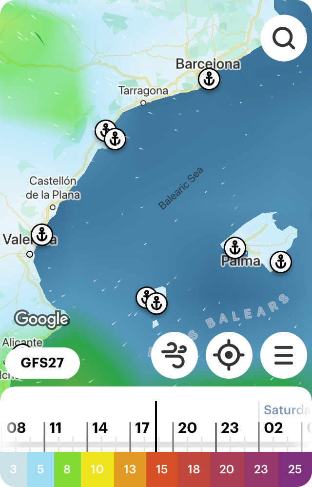
Weather Map of the Balearic Sea in the WindHus for iOS
Text: Ilya Drigo , pro meteorologist, developer, and researcher with a Bachelor’s degree in Oceanography, Meteorology and Hydrology from the Lomonosov Moscow State University (MSU), Windy.app’s ex-chief meteorologist. His favorite sports are hiking and sailing. Ivan Kuznetsov and other Windy.app authors contributed to this article
Cover photo: Renan Brun / Unsplash
You will also find useful
Nautical charts — an essential navigational tool for sailors
Find out if your yacht license is valid in different parts of the world
The beginner's guide to types and purposes of yachting boats
Review of sport centerboard boats and catamarans: types, sizes, history
The fire on board. Learn how to prevent it
Mini guide to sailing and yachting with Windy.app
How to use wind history for better weather forecasting
Latest News
Watch our webinar: fish and boat with windy.app, widgets for apple watch, presenting the sea temperature map.

Ocean Nav - Training and Coaching
Expand your Horizons
Weather forecasting is a very specialist subject. Generally speaking, weather forecasting is beyond the reach of even most professional yachtsmen. We simply do not have the resources onboard our vessels. The UK Met Office has one of the biggest and most powerful computer ever made (Cray 2 Super-computer, capable of some 14 thousand, Trillion calculations per second!)
The UK Met Office is one of only two truly global forecasters, the other is the USAs NOAA (National Oceanic and Atmospheric Administration) these two organisations monitor and attempt to accurately forecast the weather of the world.
For you and I onboard our vessel at sea, we are not really forecasting the weather. We are trying to apply the forecast to the weather around us. It rarely fits perfectly as the forecast is produced for a very large area (The Northern Atlantic Ocean, for instance) and we are only interested in just a couple of thousand square miles of the forecast area. Even if you are Coastal sailing and are using the Met Office (or other agency's forecast) you will still be dealing with a forecast that covers a lot of sea. The Met Office inshore forecast for the area North Foreland to Selsey Bill and 12 miles offshore. The straight line distance is 136 Miles x by 12 miles = 1632 square miles of forecast area. It is unreasonable to expect the same weather or sea conditions to exist across this huge area.
In very general terms I like to have three forecasts available. The idea is to plan for the worst forecast and hope for the best forecast. For my three forecasts, I would choose a Government Agency, (the UK Met Office for instance), I would then want a commercial weather service, (you can use an App for this one, maybe Predict Wind or similar) and thirdly I would look for some form of local service (Local Radio, TV or a local weather web site)
Here in Brittany I still use the Met Office, Predict Wind and I tie this in with my weather station at home.
Some basic knowledge of the Jetstream can also be of use. Most of us know that the Jetstream is a high-level fast-moving river of air that helps Airliners fly faster. What we, perhaps, don't know is that the Jetstream also acts as a barrier between the very cold polar air masses and the warmer Temperate air masses. Thus if the Jetstream moves South (as it does in the Winter) then the colder Polar air can also move South.
Because the Jetstream is this FAST moving river of air, it's pressure is also lower than the surrounding air. This lower pressure makes it very attractive to depressions, in fact, the Americans frequently refer to the Jetstream as the "Storm Track".
If you know where the Jetstream is forecast to be, then you also know where the depressions are likely to be.
There are a few good Jetstream forecasts on the web. Most will go up to 5 days ahead.
Check out the Jetstream forecast at www. http://squall.sfsu.edu/scripts/jetstream_atl_model_fcst.html Choose the North Atlantic, Big Images, then animate.
There are some useful web sites that can be of great help also.
One of my favourites is www.weathercharts.org
There are links to the UK Met Office MSLP (Mean Surface Level Analysis) charts (5 Days worth) A satellite view of Northern Atlantic and Northern Europe, this allows me to see the current cloud formations and apply what I am seeing to what the forecast shows. Differences between the forecast timing and the actual timing help me to correct the forecast to a local scale.
Whilst www.weathercharts.org site is focused on the Northern Hemisphere if you are sailing the southern seas then have a look at www.passageweather.com
This is a weather site focused upon sailors and explorers. Nice clear charts and good animations.
There are some excellent books on the weather at Sea;
RYA Weather Handbook , a decent book with much good information, easy to read and a good guide
The Sailor's Book of the Weather, (Simon Keeling). A very good first book of the weather. Simon Keeling has done a great job with this book.
Instant Weather Forecasting, (Alan Watts) The essential starter for anyone interested in weather and it's local effects. This book comprises a series of pages, each has a photo of the sky and on the facing page is the description of what is happening and what is going to happen. IDEAL FOR DAY SKIPPERS AND YACHTMASTER OFFSHORE ALIKE
The WEATHER Handbook, (Alan Watts) A superb book for those with a little knowledge. An easy way to develop that little knowledge to a greater level.
Weather for Sailors, (Bill Biewenga). Published by North ISBN 0-9744676-0-X. An advanced book for Sailors. This book presumes a good level of weather knowledge to start with. However, it does contain some excellent pieces on analysing the upper atmosphere, 300mb and 500mb charts in particular. A favourite of mine.
REEDS MARITIME meteorology, (Maurice Cornish & Elaine Ives) a superb book covering every aspect of forecasting and weather when at sea. One of my favourite books.
The SEABREEZE HANDBOOK , (Alan Watts) Sea Breeze are difficult to predict, harder to understand and can transform a coastal passage. This book gives you all the knowledge you need to manage the Sea Breeze.
Additional books that specifically mention weather would include Tom Cunliffe's Heavy Weather Cruising and Adlard Coles Heavy Weather Sailing . Both should be required reading for all yachtsmen both Power and Sail.
- Yachting World
- Digital Edition

Offshore weather planning: the options for receiving weather data at sea
- July 7, 2015
Sailing weather expert Chris Tibbs is off on a round the world cruise. He explains the options for receiving weather data at sea and reveals what he will be using
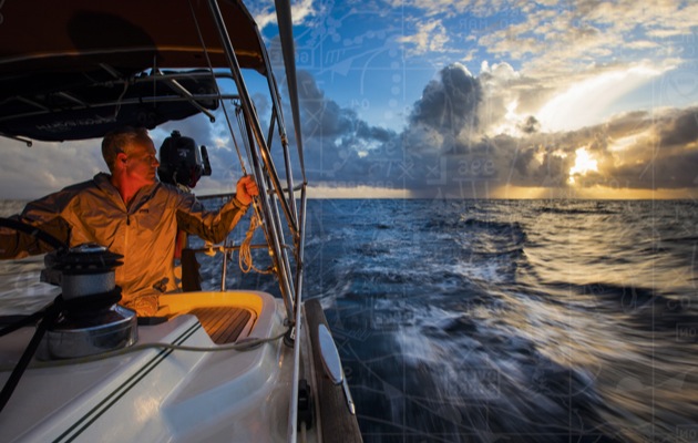
Photo credit: Tor Johnson
When I skippered a yacht in the first Atlantic Rally for Cruisers (ARC) 30 years ago the weather planning information we had after we left Las Palmas was just about zero. Navigation was chiefly via sextant.
But communications and navigation has changed immeasurably since then and with it our choices. During the last Azores and Back race (AZAB) we gybed off the direct route to jump 50 miles north, and took the leg by over seven hours on corrected time. We made that decision purely on weather information received on board via a satellite phone .
Today we are used to getting a huge amount of information from the internet, but this quickly drops off as we head offshore. On any ocean or long offshore passage communication choices are limited to satellite or radio.
However, there are still a lot of choices to be made depending on requirements and budget. It sounds as if it should be simple, but it isn’t – a bit like choosing a boat, we might think we know what we want, but how many people would have made the same decisions at the end of a passage that they did when planning it?
The best place to start is to consider what sort of basic weather information you would like to receive out at sea.
Weather information
At the top of my list are synoptic and forecast weather charts. These have not changed much over the years and give a very good overview of where systems are and where they are going. With some knowledge and practice, wind speeds and direction can be determined, expected weather near fronts, and by identifying air mass, a good estimation of conditions can be made. These charts cover the analysis and forecast for up to 96 hours and sometimes longer.

Forecast charts such as this can be obtained via weatherfax, email or downloaded online
To add more detail and to avoid having to measure isobar spacing and convert to wind speed, GRIB files can be downloaded and overlaid on an electronic chart. These are forecasts usually from the American GFS model, which for an Atlantic crossing will be the same model as the weather charts once away from Europe.
This will add detail which you may have missed in the charts and with added rainfall rates, an indication of fronts or widespread squalls.
Area forecasts cover large swathes of ocean, which make them less useful for fine-tuning a forecast, but they are good for identifying dangers. One advantage of crossing with a rally such as the ARC is the provision of a daily forecast from an experienced forecaster.
So these are my main three basics: weather charts, GRIB files and a general forecast. It would be nice to add satellite pictures, wave forecasts (which can be downloaded in GRIB forecasts) and observations, and to compare different models, along with a whole host of information that I would normally download at home, but time and cost prohibits this.
If you take the above as a basic requirement, there are a number of ways of achieving this.
For long-range communications the choice is satellite or SSB. While satellite might appear to be the up to the minute way to go, SSB radio remains a favourite for bluewater cruisers and liveaboards. By adding a pactor modem, the SSB is expanded to receive small emails and GRIB files.

Studying the waetherfax. This is old technology now but many countries still use it
Everything received at sea is slow so expectations need to change. At home with fast internet we never even think about file sizes any more, but when using either satellite or SSB we are restricted in file size by speed and/or cost.
Satellite v SSB
Before making a decision you need to ask yourself what your longer term plans are going to be. What may be suitable for an Atlantic crossing and shipping home on a freighter will not necessarily be best if this is the start of a world cruise and the boat is your home for the next few years.
Are you intending to be sending blogs and photos or running a business from on board, or do you just want the minimum of weather information at sea?
Let’s start with the basics. You can use a handheld satellite phone attached to an external antenna at one end and a laptop on the other, and will be able to receive limited emails and small attachments. It is possible to get weather charts via email as well as GRIB files for a small area (or a larger area at a lower resolution). This is what I used for both the Round Britain Race and the AZAB.
It is relatively cheap and easy to set up. You can move it from boat to boat and for two races I found it acceptable. Both were two-handed and the amount of time I wanted to sit at a chart table downloading and analysing data was limited. Cost of download was in the region of £15-20 per day.
To expand this and increase the speed of download you have to move up to a fixed system with a larger antenna. Capital costs go up, but so too does download speed, while the cost of data and calls goes down.

Satphones really need an external antenna like this
What does seem exciting is Iridium GO! This does a very similar job to the handheld satphone; for voice or data you activate it from an app on your mobile or tablet. The outstanding feature is the oft-quoted unlimited data package of US$125/month, which is very attractive. However, if using it for phone calls you are back to a higher tariff for voice.
Limitations are the apps you can use it with and the data speed, which is the same as a satellite phone at 2.4kbits/s. I therefore tend to group the GO! with the handheld phones and small antenna with the difference being in the tariffs.
A pactor modem
The SSB option is improved with a pactor modem. This addition allows you to send and receive emails and GRIB files. If you do not want to go this route, the SSB will link to a laptop and weatherfax pictures can be received via radio.
This was the mainstay of weather forecasts for many years and the excitement we felt when we first got weatherfax for ocean racing was immense. Now it is old technology, but it is robust and many countries, including the UK, US and Australia, still transmit weatherfax pictures that are the same as weather charts received via satellite. The quality is not always good and it does depend on propagation.
If you have an SSB on board I cannot see a reason why you would not have weatherfax.
However, with a pactor modem plus a subscription to Sailmail* the scope of the SSB is widened to include a great deal of weather information, GRIB files, observations, safety net messages and email. As the system works through contact to a shore station it is slow and the amount of data is limited, but with a good signal all your weather needs can be met. The subscription ($250) is yearly, then data is free.

GRIB files overlaid on charting software can be downloaded via satellite or SSB with a pactor modem
There is no easy answer. SSB is part of the GMDSS network with emergency frequencies and most places in the world have cruiser nets – rallies will also have their own network. Communication with a group is easy and gives a great feeling of belonging when alone on an ocean.
Satellite communications are more personal and not part of GMDSS, but you can pick up the phone and talk to Falmouth Coastguard in an emergency, or be put through to a hospital should you have a medical problem.
The more expensive satellite systems, where data comes more in line with an acceptable speed – although still a long way from broadband – is a matter of choice and budget.
My personal opinion is the further you are from Europe the more useful SSB becomes. In the UK you need to pass a test for a radio licence which is not necessary in the US and other countries. Therefore, more long-distance cruisers have SSB radio from these nations. The US transmits a high seas forecast on SSB and once into the Pacific and heading west the availability of voice forecasts increases on SSB.
My own choices
This year to celebrate the 30th ARC my wife and I are off on an adventure which will hopefully take us to New Zealand and possibly beyond. Our budget is limited and below I detail what we have come up with. Some of the equipment was bought second-hand on eBay; other parts are new.
First we have a basic satellite phone with an external antenna. We will use this for any necessary voice communications at sea. It will also be a back-up for receiving weather pictures from the MailASail * weather system – you send a request email and get a picture back – and we will have the facility for GRIB files and email. We will use the MailASail compression software.
We have also installed an SSB radio complete with pactor modem with Sailmail subscription. It was not a cheap option, but once away from the UK it will be good to communicate with other yachts and there will always be the weatherfax back-up. Once into the Pacific communication with other yachts becomes particularly important and this was a significant part of our decision.
If I wanted a system purely for weather on specific passages then I think I would stick with my Iridium phone and laptop. Data is severely restricted in file size, speed and cost; however, from my experience of £15-20 a day for a sensible amount of weather information, it is acceptable. The Iridium GO! is an option and the decision to go with that would depend to a large extent on price plans.
The further from the UK we travel the more sense it makes to take an SSB radio. The cost of $250 a year for data is small for a livaboard who wants to keep in touch. With the latest Sailmail compression software, along with its weather portal, a little bit of patience should give good returns in weather information.
However, if budget allows, a fixed satellite system offers faster access and each megabyte becomes cheaper. The mid-range Iridium Pilot is a popular option for those who need to keep in touch. The larger systems can also be linked to a local router, allowing access from different devices.
Even with this equipment it would be good to have an SSB as well for long-distance cruising – note that most round the world rallies require it as part of the mandatory safety equipment.
* Note: Sailmail, a service useful for SSB. MailASail useful with satphone
Chris Tibbs’s set-up

For the SSB we need:
- Pactor modem (for emails and GRIB files)
- Annual Sailmail subscription – $250, data is then free with weekly limit
- Licence to operate (long-range certificate)
The cost of the radio and installation is around £4,000. Speed depends on modem and conditions; new modems claim 5.5kbits/s in perfect conditions.
- Handheld phone and external antenna costs around £1,600 plus airtime
- Older phones need a data connector (standard on new phones)
Speed 2.4kbits/s
Iridium Pilot:
- £4,200 plus mounting pole, plus airtime, but it can be 50 times faster than a satphone and data costs are greatly reduced.
With satellite phones the airtime and contracts vary greatly and matching what you need with the right bundle is critical.
See also Chris Tibbs’s advice on Atlantic routes
Chris Tibbs
Chris Tibbs has raced round the world three times, the last time as skipper of Concert in the BT Global Challenge. After a Master’s degree in applied meteorology and a spell at the Met Office, Tibbs became a full-time meteorologist with the sailing community. He has helped many racing teams and is the author of the RYA weather handbook. Still a keen racing sailor he was overall winner of the last AZAB
How to Read Weather Charts for Sailing
Next to an accurate chart, a solid weather forecast is about the most important piece of information you can have when sailing. Weather forecasters on television stand in front of weather charts and make large-scale predictions, but they aren't usually the type of forecasts we need for sailing offshore.
Learning to read a weather chart yourself is an excellent tool to have along with professional weather forecasts and helps you learn the larger weather patterns around where you sail and where you're headed. And if you sail where there aren't good forecasts, it's important to know how to interpret the data that is available to you.
On this page:
Types of weather charts, synoptic charts, global weather in a nutshell, fronts and storms, making sense of the chart, interpreting the chart, other useful charts, resources and chart keys.
To learn to read a weather chart isn't possible without some understanding of how weather works, and learning what information is available on a chart for you to draw conclusions. But don't worry, we'll break down the basics for you so you can make some sense of that weather chart.
Most weather websites have weather charts, though they're often embellished with forecast information from meteorologists, or additional symbols and notes. But those animated screens TV weather people point at and the more developed forecasts on weather websites are based on underlying weather information.
We're going to look at the basic, uninterpreted weather charts so you can understand the underlying information and learn to interpret it yourself. Several governmental agencies provide weather charts free to anyone who wants them, like the National Weather Service in the U.S., the U.K. MetOffice , Meteo France , and almost every other sea-going nation.
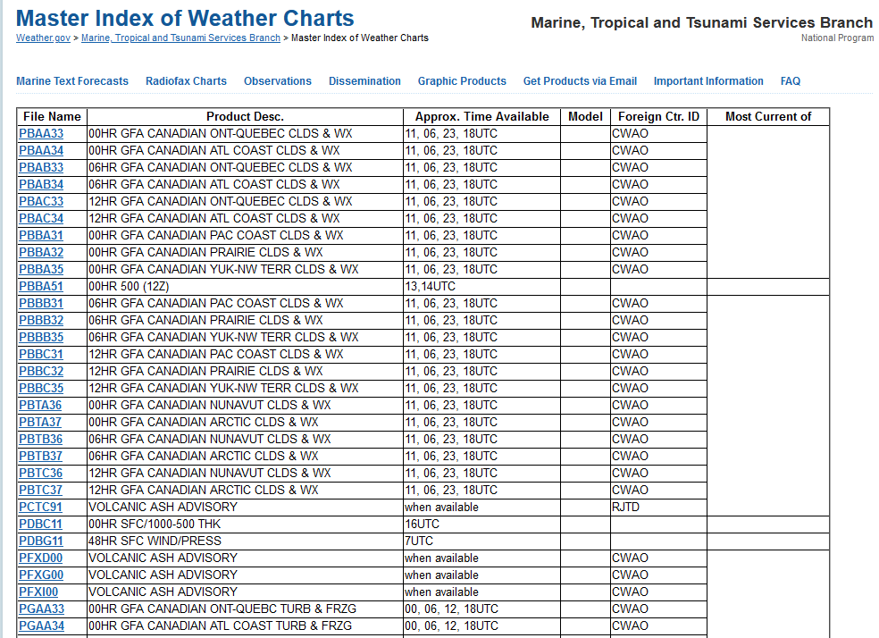
But the array of weather products is quite dizzying. The "Master Index" of weather charts from the National Weather Service has hundreds of entries, with everything from surface pressure analysis to volcanic ash advisories and ice warnings. What are the charts that you need?
The primary chart that most turn to for basic weather is the Synoptic Chart . It may also be called a Surface Analysis or a Surface Chart , because it is based on conditions and observations at the surface of the earth. It is a snapshot in time of the conditions over a large area of the planet, showing general conditions and weather systems and how they are moving.
On a surface analysis chart, you'll find the location of high and low pressure systems , fronts , troughs , ridges , and the range of air pressures, as well as some references to wind strengths, directions, and conditions. The detail on the synoptic chart will vary, as chart delivery via services like weather fax only allows for black and white charts and little detail. But full color synoptic charts may hold a lot more information than a weather fax you pull down offshore over marine SSB radio.
A synoptic chart is valid only for a certain amount of time from its creation, so always check the labels. And some charts are projections forward - what expect the chart should look like 24 or 48 hours from the time of forecast.
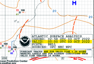
This article will focus primarily on synoptic charts and forecasts and how to use them.
You can't understand a weather chart without knowing a little about weather. Learning to read a chart is a good way to learn about weather because they two are so linked. It's like learning about a marine chart without learning a little of navigation. It makes little sense without it.
There are several overarching features of our planet which contribute to weather on a large scale. They affect the movement of weather systems, the direction of wind, and how weather is created on a global and regional level. While it's very hard to predict the exact weather for a specific town or village, studying global forces will help predict the weather over a larger area.
Atmospheric Pressure
Atmospheric air pressure, or barometric pressure , is the weight of the atmosphere pressing on the surface of the earth. Picture a column of air one inch square (2.54 cm x 2.54 cm) extending from the surface of the earth at sea level to the top of the atmosphere. That column of air normally weighs about 14.7 pounds, so this is the "normal" atmospheric pressure in pounds per square inch (psi), or one atmosphere .
Very few weather reports use PSI as a scale, as they've moved to the metric system, or the International System of Units (SI). The most common measure seen on synoptic charts is the millibar (1,013.25 mb or mbar = 1 Atmosphere), though pressure may also show in millimeters (760mm) or inches (29.92 inches) of mercury (Hg), referring to the height of a mercury column in a liquid metal barometer. Rarely will pressure be shown in Pascals (101,325 Pa), the SI measurement for pressure.
Air pressure varies with altitude, so standard pressure is at sea level and measurements taking inland at elevation are adjusted to sea level normal.
Coriolis Effect
A Coriolis "force" isn't a genuine force, it's the deflection effect on the motion of an object in a rotating frame of reference.
Picture a flat circular disc, stopped, with a ball sitting at the center of the circle. Now, push the ball out from the center, and it will trace a straight line across the circle to the edge. Now picture that disc sitting on an old-style record player, spinning. Push the ball out from the center and what happens?
It moves in a curve. Or does it? It looks like it moves in a curve, if you're sitting outside the rotation as a fixed observer. But the effect is the same. The line traced across the surface curves. There is a "spin" or curve added to the motion of the ball as it moves.
The amount of "spin" depends on the speed of rotation, as well as the interaction between the spinning surface and the ball. A felt disc with a lot of friction will affect a ball much more than a smooth surface.
So how does this relate to the weather?
Imaging the earth, spinning at one revolution per day. That's seems slow, but it's 1,037 miles per hour at the equator, or 733 mph at 45 degrees of latitude! Large moving masses of air are like that ball in the middle of that spinning disc. Their effective motion changes relative to the surface as they drag against the surface of the earth, changing wind directions and imparting spin.
In the northern hemisphere, among other effects, this deflects north moving winds to the east. The effect is opposite in the south, where winds deflect to the west. On a larger scale, the Coriolis effect contributes to the cyclonic (circular) motion of weather and pressure systems.
On a small scale, the Coriolis effect is too small to notice, but on a global scale it has dramatic effects on weather patterns.
Pressure Systems
Pressure systems are the building blocks of weather. They move around the world in mostly predictable patterns and have a few defining characteristics that let us draw some conclusions about how they'll affect surface weather as they move through our locale.
Pressure systems are linked to the temperature of the air masses. Colder air is denser, so more air can pile up on cold systems, creating high pressure. Conversely, warm air is less dense, so the air pressure above us is lower, since the air is less dense.
Please note - the general spinning movement of pressure systems in the northern hemisphere is directly opposite their movement in the southern hemisphere . For clarity, we'll talk only about the northern hemisphere, but assume everything spins the other way if you're down under unless specified otherwise.
High Pressure Systems
Colder temperatures and clear skies characterize high pressure systems. In the northern hemisphere, they rotate clockwise, and air at the surface flows out from the center of the system as cooler air in the middle presses downward and pushes it outwards.
Low Pressure Systems
Low pressure systems are warmer, and usually lead to cloudy temperatures, rain, and sometimes very severe weather. The spin counter-clockwise, and air flows INTO a low pressure system, as warmer air in the center rises and air rushes in from the sides to fill the gap.
Wind and Pressure
Wind comes from a variety of sources at the earth's surface, and all these wind forces add up to make the wind we feel.
Air flows naturally from high pressure areas to low pressure areas, creating a gradient wind , the large-scale wind caused by differences in air pressure. The gradient wind trends across enormous areas between air masses.
As mentioned above, low and high pressure systems have rotation, which causes a wind effect, and they have internal airflow and winds. The Coriolis effect doesn't cause airflow so much as deflect it to the east, but this needs to be accounted for in wind predictions.
On a local level, temperature differences between water masses or between the water and land can create additional winds, like an on shore breeze in the afternoon in most coastal areas. Land effects and structures on shore also affect local breezes, channeling, blocking, or changing directions on a micro scale, though does not influence offshore winds.
The local wind direction you feel while sailing is the combination of all the above - the general gradient wind, deflected by Coriolis forces, and local temperature and topography variations. Off shore breeze is a little more predictable and consistent because it isn't much affected by land masses.
The leading edge of a mass of air is a front , and usually represents disturbed or changing weather. A warm front is the area where a mass of warm area moves into an area dominated by cold air, and a cold front is a cold air mass overtaking warmer air.
Warm air is less dense than cold air, so a lighter warm front meeting cold air will slide up over the cold air mass. This cools the air mass and forces it to release trapped moisture into clouds and rain. This is generally more constant rain but lighter rain over a longer period than you will see from a cold front.
Cold fronts move faster than arm fronts, and will push under a mass of lighter warm air. This cools the warm are, leading to more abrupt and sometimes violent and colder weather.
When a cold front catches up to a warm font, they may combine into an occluded front . These often produce precipitation and a sharp drop in temperature in their passing.
To explain the symbols and talk a little about what you'll find on a weather chart, we'll use this Pacific Surface Analysis chart. This is a real chart from the NOAA list of Radiofax Charts for the North Pacific and Tropical East Pacific .
Study it for a minute, and see if you can guess what the symbols mean from what we learned already, and refer to it for all discussion. Most charts are available in color, which improves readability. But sometimes, you may only have black and white charts. Charts received over marine SSB and weather fax are in black in white, as are some less popular charts. Black & white images are also smaller and easier to download with limited offshore bandwidth. They contain the same information but no color codes, so recognizing the shapes and lines is more important than the colors.
At the end, we'll give you the NOAA key to all the symbols, but we'll talk you through each one on the way.
Information Box
Any weather chart will have a box describing the covered region, type of chart, issue date, and an expiration date. Given that large charts cover multiple time zones and are used all over the world, they give times and dates in Universal Coordinated Time (UTC) to avoid local time zone conversion. So you will need to adjust for local time yourself.
High and Low pressure systems are designated with a large blue H or a large red L. They will also have an underlined number near the letter. This is the atmospheric pressure reading in millibars at the center of the pressure system. The sample chart shows an intense Low with a 988 pressure reading in the Gulf of Alaska, and a high in the north Pacific off of Washington state reading 1026, among several pressure systems.
High Pressure System
Low Pressure System
Low pressure systems often have an arrow showing expected movement in the coming 24 hours, with pressure changes noted.
Each pressure system is surrounded by blobbish circles with numbers. These are isobars . Like depth lines on a chart or altitude on a topographic map, they show the lines of specific measurements - in this case, atmospheric pressure. The space between them may vary, but the closer they are together, the steeper the gradient.
The numbers are usually the last two digits of the isobar reading, to remove clutter. Referring to the 988 millibar Low in the Gulf of Alaska, you can see lines in increments of 4 mb heading out, increasing to 992, 996, 1000, and so on.
If the two digit number (XX) is low it's a 10XX mb measure, higher numbers are 9XX. So in the above example, the isobars represent 992 mb, 996 mb, and 1000 mb.
Cold fronts are long blue lines with triangles on them, and warm fronts are red lines with semi-circles. The shape is on the side of movement, so you can predict their general motion in the coming days.
Occluded fronts are shown with a mix of semicircles and triangles; on color charts, they will alternate blue and red colors.
Stationary Front
Occluded Front (in purple)
Wind Arrows and Station Plots
Wind arrows show wind speed and direction. The "feathers" show the strength, and the arrow points in the wind's direction. Each large feather represents 10 knots of wind, half feathers are 5 knots. This is an expected range within a few knots of breeze, not a precise measurement.
A station plot usually accompanies wind arrows with measured data from a vessel or land station.
This wind arrow shows 20 knot winds north-north-westerly winds. Next to it are color coded numbers keyed (clockwise from the top left) for temperature (red), dew point (green), sea surface temperature (blue, in degrees Fahrenheit on NOAA charts), atmospheric pressure (white, the last three digits including a decimal), and three-hour pressure change (orange, tenths of a mb).
This station plot shows NNW winds at 20 knots, 48°F air temperature, 41°F dew point, 52° SST (sea surface temperature), 1013.6 mb barometric pressure, with a +.2 mb increase over the last three hours.
Station plots may optionally include a ship identifier if it was reported by a vessel, present observed weather, and wave height. Colors and units also may vary by chart provider, so double check for units if you're getting data from outside U.S. based sources as it may use Celsius temperatures.
Troughs and Ridges
Sometimes an extended area of low (trough) or high (ridge) pressure can run along the edge of a pressure system, or between pressure systems. They aren't centered around a cyclonic high or low pressure systems.
Troughs are characterized by unpleasant weather, and passing trough can cause extended periods of wind and rain. As you might expect by now, a ridge of high pressure gives mild and clear weather.
Troughs (abbreviated TROF) on NOAA charts are shown with an orange dashed line, ridges with a zig-zagged yellow line.
Note that ridges and troughs are not marked consistently on all charts. Weather authorities outside NOAA may use different symbols. For example, the UK uses a bold line from a low pressure center. You can also be spot them on a chart by compressed isobars in a region of low or high pressure.
Notes, Warnings, Comments and other symbols
Text blocks and boxes may have notes and warnings on the chart. Some are quite specific in meaning, for example, gale, storm, and hurricane (HURCN) are warnings to expect a range of unpleasant conditions.
Gale = 34-47 knot winds Storm = 48-63 knots Hurricane Force = winds over 64 knots.
Depending on where you sail, you may find ice warnings, freezing spray, and other conditions noted with additional comments and symbols. Refer to the keys and links at the end of this article to puzzle out unfamiliar notations.
Reading the chart is good, but like a navigation chart, just because you learn the symbol for a buoy and what the numbers mean doesn't mean you can navigate, right? Reading the symbols is the first step, but looking for meaning in them is another thing entirely.
Creating a detailed, accurate forecast for a region is way beyond this article. There are undergraduate and graduate degree programs to help make accurate forecasts, and we know even with that much education how imprecise they still can be! Precise local predictions on a small area are difficult, and you will get the best analysis from professionals.
So why bother reading a chart yourself?
The main reason is to get a sense of the larger weather patterns, so you can plan your passages and know what weather you may expect. Even if it’s not for a passage planning, you can look ahead for conditions for your two-week summer vacation. Two weeks out isn't very accurate, but if you're watching the charts change every single day, you will see patterns emerge.
The other reason is that most "Weather" forecasts we see on TV and in papers are for people trying to figure out if they need to bring an umbrella to work or if it's time to dig out the snow blower. There is very little detailed prediction made for offshore conditions. So it's good to know for yourself what is happening, so the marine forecasts we can get make more sense.
A Thought Exercise
Suppose you're planning a long offshore passage heading west into the Pacific, and you see a high pressure system between you and where you're headed. What sort of conditions can you expect? Should you sail through it, around it to the north, or around it to the south?
Remember what we've learned about high pressure systems:
- They're characterized by milder conditions and lighter winds.
- They rotate clockwise in the northern hemisphere.
- Air flows out from the center to the edges.
By understanding these facts, you see if you plow through the middle of the system you may find yourself motoring across a light wind area. With a clockwise rotation, winds on the northern edge of the high will be more easterly with a north deflection, and at the south edge they will be more westerly with a southerly deflection. Though both will have some Coriolis deflection, it's a reasonable trend you can observe with station plots.
Since you're sailing west, if you can sail down to the southern edge of the high pressure system, you'll have more friendly winds than at the northern edge, where they'll be in your face. If that takes you too far out of the way to make your destination, that's another piece of information you have about the conditions you'll expect on the trip - plowing through the windless middle may be better than sailing upwind to the north.
Depending on the length of your trip, you can look past the current air masses and see the movement of any lows or troughs you may come across if you'll be out for a few days. The weather forecasters don't know where you're sailing, only you do.
For longer term planning and weather routing, the more you know, the better your decision making will be.
Understanding the Forecasts
The biggest takeaway from reading charts yourself is understanding the forecasts you get from a variety of sources and weather models. Most regional forecasts are pretty solid for 48 to 72 hours, but even then conditions can change quickly. So what you're looking for on the weather chart is "what's out there" that could affect the predicted conditions or affect you outside that 72 hour window.
One of the most important decisions offshore sailors make is the "go/no go" call at the start of an ocean passage. When you're facing a trip of a week or more, it's easy to get excited to depart when the weather is lovely and there are clear skies. But what will the weather look like 2-3 days later when the air masses have shifted and you're five or six hundred miles from where you started, too? Leaving in nice weather only to get pasted by a Low halfway through the trip is a terrible choice. But we have the information to minimize that risk.
You should always look at every weather source you can before sailing offshore, or even heading out for the weekend. Then, take what you've learned, look at the charts, and try to match up what you see on the charts with the forecast you saw. Then, look ahead and see what's coming that's not in the short-term forecast.
Back at the beginning of this article, we saw a long list of weather "products" offered by the National Weather Service. Every weather agency produces a bewildering array of charts, but some of these are very useful for sailors and deserve a brief mention.
Sea State Analysis
This chart shows significant wave heights and direction on a large scale. The numbers represent the average wave height of the top 1/3 of the largest waves in meters . Yes, those really are 25+ foot waves in the middle of the North Pacific. If you look at the corresponding surface analysis, you're almost certain to see a big low pressure system (or two) making the Aleutians quite unpleasant over the next few days.
The lines represent significant wave heights at the measured level (like isobars, but with wave heights). Expect them to change as you move from the center of the plot.
Like anything on this scale, these are general trends, not local specifics. You may see effects from currents, local wind variations, land formations, or islands impacting these predictions on the local wave direction and height.
Upper Air Charts
The large-scale movement and formation of pressure systems is driven by wind above the surface, where jet streams and cold, fast winds constantly blow and shift. The tool to look at these is the Upper Air, "500 Mb", or Constant Pressure Chart . Our atmosphere is not uniform, and you can easily see there are different winds at different altitudes by observing high cloud movement compared to local wind direction.
Instead of pressure numbers and lines on the isobars, the numbers on the 500 mb chart show the altitude, in decameters, of where the air pressure reads 500 mb of pressure. A decameter is 10 meters, so just add a zero to any number on this chart to see how high in meters the 500 mb readings can be found.
Meteorologists read this to see the amount of spin and direction in upper air systems, and how larger masses are moving and being driven.
Ice Limits, Cyclone Danger, and Satellite photos
If you're sailing at extreme latitudes, NOAA publishes charts of estimated ice field and iceberg danger areas. During hurricane season, they show risk areas for hurricanes and cyclones on a specific chart focused on just that data. And satellite photos of forecast areas show cloud cover and make spinning storm systems very apparent.
Commercial weather sites often have composite charts with much of this data available as overlays, where you can selectively add and remove detail that interests you.
We've thrown a ton of information at you in this article, and there's no way you'll remember it all. To help you, bookmark this article and refer to some keys we've linked to below. All the major weather providers have this information on their websites...somewhere!
Print out what you need for a quick reference, and look through each of these resources for more in-depth explanations of these topics.
NOAA Ocean Prediction Center - Terminology and Weather Symbols . An excellent decoding of chart symbols and abbreviations, with explanations of basic terms.
NOAA Graphical Products Legend (from the link above)
NWS Constant Pressure Charts - an overview of how to read a 500 mb chart and how meteorologists use the data.
National Weather Service JETSTREAM - a completely free online weather school, where you can take a much deeper dive into everything we've talked about.
Leave a comment
- Maritime Education & Training

Sailing Essentials: What Every Yachtsman Should Know
- Posted by Primo Nautic
- Categories Maritime Education & Training
- Date June 13, 2024
Last Updated on June 13, 2024
Every yachter is expected to develop skills that are the cornerstone of efficient and safe maritime operations. These skills encompass many competencies related to performing tasks and understanding the vast sea, the ship itself, and the ever-changing environment where yachters operate.
The following are some of the top sailing essentials and yachting tips before setting sail to ensure vessel and sailor safety throughout the journey.
Communication Skills
Effective communication is critical for safe and efficient maritime operations. Yachtsmen should be skilled at using different communication tools, from traditional sound signals and signal flags to modern digital communication systems and VHF radios.
Familiarity with maritime communication protocols, including bridge-to-bridge communications and distress signaling, will ensure the clear conveying of messages that all involved parties can understand easily.
Aside from mastery of communication tools, yachters should also hone solid and practical interpersonal communication skills. Communicating correctly with other vessels, port authorities, and crew members improves situational awareness, coordination, and teamwork.
Concise and clear communication is essential during emergencies, where misunderstandings may result in erroneous responses or delays.
Participating in communication drills and training programs can improve a yachtsman’s confidence and communication skills. Real-life exercises and simulated scenarios offer practical experience in using communication protocols and equipment, preparing yachtsmen for maritime communication challenges.
Emphasizing communication skills as part of sailing essentials reflects the importance of coordination and collaboration to ensure safe and successful maritime operations.
Rope Handling and Knot-Tying
Knot-tying is one of the most fundamental yachting tips critical for almost everything, from handling cargo to securing vessels. Tying knots properly can make a big difference between sailor safety and sea disaster.
Essential knots like the bowline, popular for its ease of untying and strength, the reef knot, which joins two ropes of the same thickness, and the clove hitch, perfect for attaching ropes to objects, are the fundamentals of a yachtsman’s knot-tying repertoire.
But more than knowing how to tie knots properly, sailors should also develop proficiency in rope handling. It includes understanding the different types of ropes used for sailing, the specific properties, and their respective maintenance and care practices.
Skills in rope handling ensure safe and efficient task performance, preventing equipment damage and accidents. Proper stowing, deploying, and coiling of ropes are as important as the knots tied in them to ensure they can be used readily when needed.
Regular practice of these skills is important to maintain proficiency. One of the best yachting tips is for sailors to stay informed about the new techniques and materials that can improve efficiency and safety in rope handling and knot tying.
Training sessions and workshops provided by established maritime institutions and experienced mariners provide yachters valuable opportunities to hone their skills and learn straight from the best in the industry.
Navigation Basics
Navigation is the science and art of safely guiding vessels from point to point. Basic navigation skills are requisite for yachters. It includes using compasses, charts, and other traditional tools to identify a vessel’s position and chart its respective course.
Yachtsmen can effectively and safely navigate marine environments if they understand primary coastal navigation, current predictions, and tidal calculations.
Traditional navigational skills remain vital even in this modern age of electronic navigation systems and GPS. The existing electronic systems can become unreliable or fail, particularly during severe weather conditions or in remote areas. A yachtsman’s ability to switch to celestial navigation using a nautical almanac and sextant or dead reckoning, estimating the position of a vessel according to course, time, and speed, serves as a crucial backup.
Continuous practice and learning are the secrets to mastering navigational skills. For sailor safety, sailors should take advantage of educational courses in maritime institutions and online to broaden their understanding of navigation techniques and principles. Participating in practical navigation simulations and exercises can also enhance yachters’s ability to navigate any situation confidently.
Emergency Response and Safety Procedures
Emergency response skills and safety procedures are essential to ensure that yachters can effectively manage incidents and address risks at sea. All crew members must know about safety protocols such as fire response and prevention, abandon ship drills, and man-overboard procedures.
Familiarity with the safety equipment on the vessel, including emergency position-indicating radio beacons (EPIRBs), flares, life jackets, and life rafts, allows effective and safe responses during emergencies.
Regular training exercises and drills are critical to maintaining readiness and ensuring crew members master all safety procedures. These drills offer opportunities to perform emergency responses in controlled environments, allowing crew members to hone their skills and pinpoint areas for improvement.
An effective emergency response depends on clear communication, strong leadership, and crew members’ familiarity with their responsibilities and roles during emergencies.
Yachtsmen must also stay updated regarding the latest equipment advancements and safety protocols. Participating in safety training programs offered by maritime safety institutions and organizations can also enhance sailors’ preparedness and knowledge for emergencies. Emergency response preparedness and commitment to safety are proof of sailors’ competence and professionalism, emphasizing the importance of these sailing essentials.
Vessel Repair and Maintenance
Vessel repair and maintenance are also crucial yachting tips to ensure that vessels stay efficient, seaworthy, and safe. Regular maintenance routines and inspections help pinpoint and solve potential problems before they become significant concerns or failures.
Yachtsmen must be familiar with fundamental maintenance tasks, such as maintaining navigational aids, engine checks, and hull cleaning, to maintain the vessel’s performance and condition.
The ability to carry out simple repairs is also crucial for sailor safety. It includes troubleshooting common engine issues, replacing worn lines or ropes, and patching leaks. Although professional intervention may be required for major repairs, a sailor’s ability to deal with minor problems can avoid further damage and guarantee the vessel’s ongoing operability.
Training and vessel repair and maintenance education significantly impact a sailor’s proficiency in these areas. Most of today’s maritime organizations and institutions offer workshops and courses that cover all the basics of systems repair, hull maintenance, and marine engineering.
The hands-on experience acquired through participating in maintenance works with seasoned mariners as guides is invaluable for developing these essential skills for sailors.
Weather Understanding and Forecasting
Understanding and forecasting the weather is also a crucial skill for yachtsmen. It enables them to predict and respond to weather conditions that significantly affect maritime operations.
Basic knowledge of barometric readings, cloud formations, and weather patterns allows yachters to make wise decisions about safety measures, speed adjustments, and route planning. Familiarity with different tools for weather forecasting, such as marine weather services, weather maps, and satellite imagery, further improves a sailor’s ability to anticipate and prepare for weather changes.
Applying knowledge about the weather to sailing essentials involves avoiding adverse conditions and harnessing favorable ones. Yachtsmen must master accurate interpretation of weather forecasts, understand the limitations of models for weather predictions, and devise contingency plans for unforeseen weather changes. This skill set is particularly critical for areas exposed to severe weather and for long voyages where decisions made right on time can ensure vessel and sailor safety.
Continuous weather monitoring and regularly participating in weather briefings are essential yachting tips. Attending courses and workshops on marine meteorology can also offer deeper insights into forecasting strategies and weather phenomena. Incorporating an understanding of weather conditions into daily operations shows how vital this skill is to ensure efficient and safe maritime travel.
Environmental Conservation and Stewardship
Environmental conservation and stewardship are becoming acknowledged as essential bare sailing skills. Sailors play an important role in protecting the marine environment through practices like responsible waste management, avoidance of sensitive ecological spots, and reduced emissions. Awareness of the environmental impact of maritime activities motivates yachters to follow sustainable practices that can contribute to marine life and the health of the oceans.
Implementing environmental stewardship practices involves understanding and familiarizing yourself with the guidelines and regulations for environmental protection during maritime operations. It includes adherence to global conventions on marine pollution and joining initiatives meant to reduce the ecological footprint of different sailing activities.
Yachtsmen should also be proactive in identifying and applying the best environmental conservation practices, including participating in projects for marine conservation and reducing energy consumption onboard.
Training and education in environmental stewardship can improve a yachter’s understanding of seamanship and its ecological aspects. Most maritime educational institutions and organizations offer resources and courses on sustainable sailing practices, marine ecology, and pollution prevention.
Sailors can help preserve marine environments if they embrace environmental stewardship, emphasizing the essence of sustainability in today’s seamanship.
Previous post
Key Parts of a Ship Explained
Revolutionizing navigation: ai role in modern shipping, you may also like.

Maritime GPT: Revolutionizing Maritime Education with AI Models

Abandon Ship Protocols: Ensuring Safety When All Else Fails

From Classroom to Deck: The Evolution of Maritime Education Platforms
We use cookies to enhance your experience and analyze site usage. By clicking 'Accept', you consent to our use of cookies. For more information, please see our Privacy Policy .

Download App
Learn on-the-go with primo nautic app.
The Primo Nautic App brings maritime courses to your fingertips. Study anytime, anywhere, track your progress and easily bookmark crucial content.

- All Courses
- RYA Start Yachting
- RYA Competent Crew
- Novice to RYA Day Skipper
- RYA Day Skipper Fastrack
- RYA Day Skipper Practical
- RYA ICC Flotilla Course
- Sailing Refresher
- RYA Coastal Skipper Combined
- RYA Coastal Skipper Practical
- RYA Yachtmaster Coastal
- RYA Yachtmaster Offshore
- All Adventures
- Mile Builders
- Gibraltar to Africa Weekend Adventure
- Round the Island Race
- KMT Sailing : Cultural adventures under sail
- All Yachtmaster Courses
- Professional Yachtmaster Fastrack program
- RYA Yachtmaster Theory
- Extended Yachtmaster Preparation
- Passage Making and YM Preparation Course
- Online Courses
- RYA Online Theory Course
- RYA Online VHF / SRC
- RYA PPR Online Course
- Yacht Charter Gibraltar
- Full Day Charter and Half Day Charters
- Frequently Asked Questions
- Joining Instructions
- Special Offers
- Gift Vouchers
- Pre Course Experience
- How to Get Here
- Why Choose Jolly Parrot
- Jolly Reviews
- Where We Sail
- Our Jolly Fleet
- Helping You Choose
- Where are the Parrots?
- Gibraltar Weather
- Sailing Glossary
- Jolly Links
- Terms & Conditions
- Photo Gallery
How to interpret a shipping forecast
26 October 2016
In the UK, the Shipping Forecast is currently provided by the UK Met Office and is regularly broadcast on BBC Radio 4 on behalf of the British Maritime & Coastguard Agency.
It is broadcast at 0048 hrs on FM and LW (including reports from coastal stations, an inshore waters forecast and brief UK weather outlook). The forecast is broadcast also at 0520hrs (FM & LW), 1201 hrs (normally LW only) and at 1754hrs (LW on weekdays and FM and LW at weekends).
The broadcast format is limited to 370 words and has a very strict format. This is so as to simplify and standardise the delivery of what is a lot of detailed information. The format is as follows;
- Time and Date of the active forecast being read
- List Gale Warnings current around the British Isles
- General Synopsis
- Area Forecasts
- Inshore Waters Forecast
The sea areas around the British Isles and the Western Coast of Spain, Portugal and Ireland are included in the forecast. This has relevance as in the UK most prevailing weather systems arrive having passed through the North Atlantic.
Making sense of the Information
The time the forecast was issued is critical as all other times and estimates relate to it. The time of the forecast may be different to the time of the broadcast. Listen!
Listening to what is happening in the South West and Western Approaches to the Channel is likely to give you a good idea of what to expect tomorrow South of the Solent, dependent on the track of the low and high pressure systems and their speed. So listening to the synopsis and the surrounding areas will give you a good idea of what’s to come.
Make notes as you go. Ideally you will use an easily identifiable shorthand that all can read but if you have your own make sure you ‘translate’ the relevant information and log it for their information.
A typical forecast for several sea areas might be;
"Humber, Thames. Southeast veering southwest 4 or 5, occasionally 6 later. Thundery showers. Moderate or good, occasionally poor."
What this is telling us is that the sea areas Humber and Thames (basically a large part of the western North Sea from Hull to the Dover Straits) is forecast to experience a SW wind direction blowing Force 4 or 5, sometimes F6 later. ‘Later’ is specifically at at time over 12 hours from the time the forecast was ISSUED.
Force 4 or 5 might seem to be of little worry, even to most yachtsmen, especially if they are heading North up the West coast of the UK in the lee of the mainland on a broad reach. In fact, if you keep listening, the Inshore Waters Forecast for your area might well reflect that rationale and wind strengths and sea state might be significantly less as a result.
However, the fact that a F6 is forecast later should make you think about your plan, especially with thundery showers and occasionally poor visibility forecast.
A Beaufort Wind Strength Force 4 is an average of about 15 knots. That is pleasant sailing for most. Even a Force 5 from abaft the beam is usually nothing to worry about. Using a quick ready-reckoner, we can soon work out that a F5 is likely to deliver about 20 knots (The Force - in this case 5 - minus 1 = 4 x 5 = 20kts). This works well as a mean wind strength conversion from the Beaufort Scale to knots.
A Force 6, coupled with veering winds (moving clockwise), which are likely to put the wind on the beam or forward of the beam when sailing, potentially increasing the sea state (especially if blowing down the coast against a flooding tide) is a different animal altogether. And the visibility is dropping too. Thundery showers, poor visibility, wind veering and increasing. Sounds like a front could be blowing through to me.. Let’s keep an eye on the barometer and consider a change of course. What was our nearest port of refuge in our passage plan? How about we set a course for that sheltered port and enjoy some pub grub tonight?
To clarify the terminology further, see our Beaufort Scale article for easy reference;
Further definitions used in the shipping forecast:
Good = >5 n miles Moderate = 2 - 5 n miles Poor = 1,000 metres - 2 n miles Very Poor = Less than 1,000 metres
Imminent = Within 6 hours of issue Soon = 6 - 12 hours of issue Later = >12 hours from issue
SPEED OF PRESSURE SYSTEMS
Slowly = Moving less than 15 kts Steadily = 15 - 25 kts Rather Quickly = 25 - 35 kts Rapidly = 35 - 45 kts Very Rapidly = >45 kts
Direction = The direction from which the wind is blowing Becoming Cyclonic = Indicates a significant change in wind direction across the path of a depression Veering = Wind direction moving clockwise Backing = Wind direction moving anti clockwise
AIR PRESSURE TENDENCY
Rising (or falling) more slowly = Pressure rising (or falling) at a progressively slower rate through the preceding three hours Rising (or falling) slowly = Pressure change of 0.1 to 1.5 hPa in the preceding three hours Rising (or falling) = Pressure change of 1.6 to 3.5 hPa in the preceding three hours Rising (or falling) quickly = Pressure change of 3.6 to 6.0 hPa in the preceding three hours Rising (or falling) very rapidly = Pressure change of more than 6.0 hPa in the preceding three hours Now rising (or falling) = Pressure has been falling (rising) or steady in the preceding three hours, but at the time of observation was definitely rising (falling)
Understanding the information provided is one thing. Being able to interpret it and make a safe plan as a result takes knowledge and experience.
Call 07925 784407 and ask us about RYA Sailing Courses offered in the tidal waters of the Western Mediterranean from our Gibraltar base.
Related articles:
- Best Books on Weather for Yachtsmen
- Sources of Weather Forecasts for Sailors
- How to Prepare a Yacht for Sailing in Heavy Weather / Storm Conditions
- How to Use a Barometer when Sailing
Other Blog Articles
What is a saloon berth.
30 May 2024
Why learn to sail in Gibraltar?
The pros and cons of in-mast furling.
- AMERICA'S CUP
- CLASSIFIEDS
- NEWSLETTERS
- SUBMIT NEWS
Boats for sale
- Met Office Marine Weather (including Shipping Forecast and Inshore Forecast )
- Met Office Weather Observations Website a UK initiative by the Met Office, the Royal Meteorological Society and the Department for Education
- BBC UK Coastal Forecast
- yr.no - Worldwide Forecasts
Cloud, Pressure and Wind Charts
- Met Office Surface Pressure Charts (updated daily around 0730 UTC)
- BBC UK Cloud and Pressure Maps
- WeatherOnline Wind Charts
- Met Office Infrared satellite animation
- Met Office Visible satellite animation
- Windology - wind predictions for the UK and Ireland for the next 6 days
- BBC Tide Tables
- Admiralty EasyTide
- Met Office UK Overview
- BBC UK Overview
- Met Office Europe Overview
- Met Office World Overview
- Frank Singleton's Weather and Sailing Pages
- UK Weather Cams
Observations
- NOAA National Data Buoy Centre
- XCWeather live weather readings from airports and bouys around the UK
- Channel Coastal Observatory
- Abersoch Weather Station
- Brambles Post (Central Solent)
- Chichester Bar Beacon (Eastern Solent)
- Cowes Harbour Weather
- Dun Laoghaire Harbour Weather
- Highcliffe (Internet Explorer only)
- Hurst Castle (Internet Explorer only)
- Portland Harbour (Internet Explorer only)
- Lymington Platform (Internet Explorer only)
- Aberdeen & Stonehaven Yacht Club
- Aldeburgh Yacht Club
- Alexandra Yacht Club, England
- Altona Yacht Club
- Amarilla Sailing Club
- Anchorage Yacht Club, New York
- Bainbridge Island Marina and Yacht Club
- Bala Sailing Club
- Beaumaris Yacht Club, Australia
- Bexhill Sailing Club
- Blairgowrie Yacht Squadron
- Bolton Sailing Club
- Brancaster Staithe Sailing Club
- Bray Sailing Club
- Brean Land Yacht Club
- Brightlingsea Sailing Club
- Bristol Avon Sailing Club
- Budworth Sailing Club
- Calshot Cats
- Calshot Sailing Club
- Canberra Yacht Club
- Castle Semple Sailing Club
- Circolo Surf Torbole
- Circolo Vela Torbole
- Club Nàutic Cambrils
- Club Naval de Yates Micalvi
- Club Velico Castiglione della Pescaia
- Coconut Grove Sailing Club
- Colne Yacht Club
- Coniston Sailing Club
- Dale Yacht Club
- Derwent Reservoir Sailing Club
- Discovery Bay Yacht Club, Hong Kong
- Docklands Sailing & Watersports Centre
- Draycote Water Sailing Club
- Drummoyne Sailing Club
- East Lothian Yacht Club
- Felixstowe Ferry Sailing Club
- Felpham Sailing Club
- Fraglia Vela Malcesine
- Fraglia Vela Riva
- Frampton on Severn Sailing Club
- Great Moor Sailing Club
- Guernsey Yacht Club
- Gurnard Sailing Club
- Harris Bay Yacht Club
- Hayling Island Sailing Club
- Hempstead Harbour Club
- Hurst Castle Sailing Club
- Island Yacht Club, Lake Ontario
- Isle of Sheppey Sailing Club
- Keauhou Kona Yacht Club
- Keyhaven Yacht Club
- Lake Canyon Yacht Club
- Lake Lanier Sailing Club
- Le cercle nautique de Loctudy
- Lega Navale Italiana Portoferraio
- Littleton Sailing Club
- Maidenhead Sailing Club
- Maui Boat and Yacht Club
- McCrae Yacht Club
- Medway Cruising Club
- Melbourne Yacht Club, Florida
- Merioneth Yacht Club
- Mount's Bay Sailing Club, England
- Neilson Vassiliki
- New Bern Grand Marina and Yacht Club
- Newport Harbor Yacht Club
- Northampton Sailing Club
- Nur Shrine Yacht Club
- Padstow Sailing Club
- Parkstone Yacht Club
- Point Lookout Yacht Club
- Point Yacht Club, South Africa
- Poole Yacht Club
- Poughkeepsie Yacht Club
- Queenscliff Cruising Yacht Club
- Real Club Martimo de Santander
- Real Club Nautic Port de Pollenca
- Regattaverein Brunnen
- Ripon Sailing Club
- Royal Brighton Yacht Club
- Royal Dorset Yacht Club
- Royal Norfolk & Suffolk Yacht Club
- Sagamore Yacht Club
- Santa Barbara Yacht Club
- Sausalito Yacht Club
- Scaling Dam Sailing Club
- Seabornia Yacht Club
- Sheerness weather station
- Shotwick Lake Sailing
- Shropshire Sailing Club
- Sorrento Sailing Couta Boat Club
- Sotogrande Yacht Club
- South Caernarvonshire Yacht Club
- Starcross Yacht Club
- Staunton Harold Sailing Club
- Studentischer Regattaverein Greifswald
- Tewkesbury Cruising & Sailing Club
- Thorpe Bay Yacht Club
- Ullswater Yacht Club
- Union-Yacht-Club Attersee
- Upper Thames Sailing Club
- Waccamaw Sailing Club
- Watch Hill Yacht Club
- Wayzata Yacht Club
- West Riding Sailing Club
- Westernport Yacht Club
- Weymouth & Portland Sailing Academy
- Whitehaven Sailing & Boating Association
- Whitstable Yacht Club
- William H. Seward Yacht Club
- Yacht Club Costa Smeralda
- Yacht Club Ibiza
- Yacht Club of Greece
- Yacht Club Parma
- Yacht Club Punta Sardegna
- Yacht Club Santo Stefano
- Yacht-Club Lister
- Yachtclub Steinhuder Meer
- Yachting Club De La Pointe Rouge
YY Online Services Ltd. can accept no responsibility for accuracy of weather or tides. Do not use the tides given as a basis for any decisions that could result in harm to people, other organisms, or property. Please check predictions against officially sanctioned tables.
- New Sailboats
- Sailboats 21-30ft
- Sailboats 31-35ft
- Sailboats 36-40ft
- Sailboats Over 40ft
- Sailboats Under 21feet
- used_sailboats
- Apps and Computer Programs
- Communications
- Fishfinders
- Handheld Electronics
- Plotters MFDS Rradar
- Wind, Speed & Depth Instruments
- Anchoring Mooring
- Running Rigging
- Sails Canvas
- Standing Rigging
- Diesel Engines
- Off Grid Energy
- Cleaning Waxing
- DIY Projects
- Repair, Tools & Materials
- Spare Parts
- Tools & Gadgets
- Cabin Comfort
- Ventilation
- Footwear Apparel
- Foul Weather Gear
- Mailport & PS Advisor
- Inside Practical Sailor Blog
- Activate My Web Access
- Reset Password
- Customer Service

- Free Newsletter
Blue Jacket 40 Used Boat Review

Catalina 270 vs. The Beneteau First 265 Used Boat Match-Up

Ericson 41 Used Boat Review

Mason 33 Used Boat Review

How to Create a Bullet-Proof VHF/SSB Backup

Tips From A First “Sail” on the ICW

Tillerpilot Tips and Safety Cautions

Best Crimpers and Strippers for Fixing Marine Electrical Connectors

Polyester vs. Nylon Rode

Getting the Most Out of Older Sails

How (Not) to Tie Your Boat to a Dock

Stopping Mainsheet Twist
Fuel Lift Pump: Easy DIY Diesel Fuel System Diagnostic and Repair

Ensuring Safe Shorepower

Sinking? Check Your Stuffing Box

What Do You Do With Old Fiberglass Boats?

Boat Repairs for the Technically Illiterate

Boat Maintenance for the Technically Illiterate

Whats the Best Way to Restore Clear Plastic Windows?

Stopping Holding-tank Odors

Giving Bugs the Big Goodbye

Galley Gadgets for the Cruising Sailor

The Rain Catcher’s Guide

Sailing Gear for Kids

What’s the Best Sunscreen?

UV Clothing: Is It Worth the Hype?

Preparing Yourself for Solo Sailing

R. Tucker Thompson Tall Ship Youth Voyage

On Watch: This 60-Year-Old Hinckley Pilot 35 is Also a Working…

On Watch: America’s Cup

On Watch: All Eyes on Europe Sail Racing

Dear Readers
- Marine Electronics
Getting Weather Data at Sea
A delivery skipper assesses the options for portable forecast options..

As a USCG Master who does offshore deliveries, I rely on accurate and current weather forecasts. After exploring several options, I finally settled on a satellite-based system that not only enables me to get affordable, accurate forecasts, but is portable enough to take with me from boat to boat. In this part one of a two-part series, I’ll describe some of the options for obtaining weather data.
The first step in evaluating how to get weather at sea was to identify the options. Once outside the range of NOAA VHF radio broadcasts there are six general methods of getting weather aboard:

1. Single side band (SSB) transceiver, almost always through a permanently mounted.
2. SSB receiver, often temporarily mounted, although it could be a permanently installed.
3. Satellite hotspot, such as Iridium Go
4. Black box satellite weather devices like Sirius XM.
5. Satellite telephone, such as the Iridium 9575.
6. Satellite messenger, such as Garmin inReach Explorer+.
Each of these methods have their own strengths and weaknesses. Keep in mind that my decision was based on my particular needs as a delivery skipper—many sailors will have other priorities.
The PS archives library has a wide range of articles on this topic, found by searching under the term “weather.”
SSB Transciever
A fix mounted SSB radio remains an important part of communications for offshore vessels. But, particularly for a delivery skipper who moves from boat to boat, it has some shortcomings that modern alternatives have overcome. The SSB allows you to receive text, charts, and GRIBS (gridded binary “raw” weather data files generated by the US NOAA/NCEP). File size depends upon the amount of data requested and can be from a few tens of Kb upwards. Although you can automate the process, getting weather products dirctly via SSB requires the radio to be on, a modem connected, and a computer connected during the time of broadcast.
An alternative method to get GRIBs is to use an email service such as SailDocs (the originator of this service), or the many services that now that now provide GRIBs upon request. These servers respond within a 1-2 minutes with the requested data. Requesting the file directly allows one to get the GRIBs when the radio is manned and are ready. It is a good option if you already have a fixed SSB radio. You can also receive weather from weather routers like Chris Parker.
WEATHER COMMUNICATION
| DEVICE | PORTABILITY | EASE OF USE | COST |
|---|---|---|---|
| SATELLITE MESSENGER | Yes | Good | $$ |
| SSB RECIEVER | No | Fair | $ |
| SSB TRANSCIEVER | No | Fair | $$$ |
| BLACK BOX (SIRIUS XM) | No | Good | $$$$ |
| SATELLITE HOTSPOT | Yes | Good | $$ (does not include service fees) |
| SATPHONE | No | Good | $$ (does not include service fees) |
In addition to its ability to collect weather, an SSB is a powerful communication tool, allowing you to reach other ships at sea, as well as participate in the Global Maritime Distress Signaling System.
SSB Receiver

A single-sideband receiver is the least expensive way to receive weather, but you must often have an antenna installed to get good reception. Like SSB transceivers they have the ability to receive information from weather routers. They also do not have the ability to provide tracking. As such, the router will not know your location and can only provide a generic weather forecast.
Satellite Hotspot

Hot spots provide two-way text and voice communication, like SSB send/receive one can request and receive specific GRIB files. Hot spots can send tracking information, but one must engage a mapping service to see the track, or even location on a map. To use the hotspot requires a smartphone, tablet or computer. Hotspots also provide text and voice communications. The popularity of the device has prompted a number of new services that focus on delivering on-demand cloud-based forecast products, including Predict Wind ( www.predictwind.com ), Luck GRIB ( www.luckgrib.com ), Sea Tech ( www.sea-tech.com ), OCENS ( www.ocens.com ) and others.
Black Box Devices
At $60 a month (not including the black box reciever) and with only a limited number of weather forecast products, subscription services like the Sirius XM weather, which can be integrated into a chartplotter, were not an option for me.
Satellite Telephone
Satellite phones offer the same functionality as a hotspot, with the addition of voice. Satellite phones like the Iridium 9575 Extreme, need to be connected to a computer—via the Iridium hotspot or a USB to collect weather data, which requires an external antenna.
Satellite Messengers
Messengers are standalone device. Until recently I only used a previous version of the Garmin inReach. The ability to text provides an easy means of communication. They also offer tracking. The messenger can send/receive text messages with no additional devices, although connecting a smartphone via Bluetooth makes typing easier.
The messenger can receive weather as well as send/receive written updates from a weather router. Using the Garmin automated weather system, a prudent captain can also track moving weather patterns. It is also possible to get weather routing through an inReach by leveraging cloud routing services like www.fastseas.com, but the 160 word limit can be constraining.
One chief difference between a portable satphone and single-sideband radio is that the former is typically point-to-point device-one caller contacting one or more designated recipients. An SSB transmission can be received by any device within broadcast range listening on that frequency. As with any apples-to-oranges comparison of two different systems providing similar functions (both SSB and a satphone can deliver voice communications and email, for example) both will invariably have pros and cons.
Operationally, the most obvious advantage of a satellite phone is its familiar form and operation. Even a non-sailor who has never used a VHF can probably figure out how to use a satphone. Another advantage is that its easy to call a landline phone with a satphone. And, for the sailor who likes to do his own installations, the satellite device greatly simplifies setup.
A satellite phones portability is also a plus. You can bring it on shore excursions, or even bring it with you should you need to abandon ship.

There are also cons to handheld sat phones: just like cell phones, handheld portable satphones are not meant to provide ship-to-ship safety communications or communications with rescue vessels or aircraft. Private party contractors like GEOS Alliance will help route rescue calls placed via satellite devices to the Coast Guard, but the U.S. Coast Guard doesn’t advocate cell phone or satellite phone as a primary means for making distress calls. They have proven, however, to be a very effective backup.
One of the main reasons sailors choose a marine SSB over a satellite phone is so that they can participate in various regional safety and cruising nets that allow cruising sailors to stay in touch and share local knowledge-and if needed, ask for help. You don’t, of course, need a transceiver to simply listen to these stations or nets-an ordinary portable multi-band radio that can tune into SSB frequencies will do.
An additional safety benefit of the modern SSB is Digital Selective Calling (DSC). DSC is an essential element in Global Maritime Distress and Safety System. All commercial ships mandated to have DSC are required to monitor DSC marine SSB frequencies while at sea. In the event of an emergency, they can receive your exact location and nature of distress at the push of a button.
As with VHF DSC, the DSC function effectively takes the search out of search and rescue, allowing rescue agencies (or nearby Good Samaritans) to provide immediate assistance, rather than waste valuable time trying to locate you first.
Although direct cost comparisons between SSB and satphones will depend on the particular unit or system being considered, its fairly typical to find that the initial cash outlay will likely be a bit less for a portable satphone (particularly if installation costs of the SSB are factored in). However, a more accurate assessment is lifetime cost, which can be determined by factoring in the costs associated with each system over the years—.
For over-the-counter portable satphones, lifetime cost ultimately depends on the service plan selected, but it can mean hundreds of dollars in annual, recurring costs. For SSB, unless you’re utilizing some type of commercial service (for weather routing, email, etc), transmitting and receiving over the airwaves is free, and free is good.
Observations
Satellite messenger subscriptions services have a few shortcomings. First, while doing a transatlantic delivery the weather forecasts provided through the device stopped working. I emailed the firm that provided them. My email explained that we were mid-Atlantic.
It was impressive to receive a response in an hour. The weather service provider advised me to contact Garmin. I sent an email to the Garmin support team explaining my situation. Instead of responding to the inReach, Garmin emailed me at home. Fortunately, my wife monitors that email account and relayed the message. Garmin advised that the weather forecast would be down “for a few days.” I believe all three of us aboard “cursed like sailors.”
Using my account with Chris Parker, we were able to get forecast and guidance. Although Chris is a very competent router and for the crossing, I like to take control of my own routing. Without GRIB files, it felt like I was sailing blind.
The inability to see GRIBs and the failure of the integrated weather forecasting relay was motivation for upgrading my onboard weather receiving equipment.
Rugged hardware is important. Marine devices need to need to particularly resistant to water intrusion at connections.

The satellite messenger was eliminated as a primary means of weather collection for the reasons cited above.
The SSB options were eliminated for a few reasons. First as a delivery captain, whatever I bring has to be easy to; carry, install, use, and remove from each boat. SSB also does not provide tracking information. Therefore, the SSB transceiver was not an option for me.
Lowest on my list of options was SSB receive-only. It is too cumbersome, did not provide a means for owners to communicate and did not provide a tracking service. Boat owners like to see where their boat is.
Satellite telephones and hotspots were both considered. The telephone option was eliminated as the connection to a computer was wired. This brought me to the Iridium GO. It was simple, raise the antenna, use an optional small antenna mounted to the rail or in the cockpit and download. After investing $699, I was the proud owner of an Iridium GO. So far, I am very satisfied with the results. Next month we’ll look at Predict Wind an extremely helpful Weather App to pair with the system.
RELATED ARTICLES MORE FROM AUTHOR
13 comments.
There are different approaches in determining what is best for your offshore weather gathering needs. This is a good look at offshore weather choices from a business point of view that has mobility issues and can write off all expenses… what about a nonbusiness approach.
As I wrote in the article, this comes down to personal choices. When a customer asks me this type of question, I respond with “How will you be using the boat?” Mostly coastal cruising? Then downloading GRIBs over WiFi or a cell phone hot spot will be fine. Even a hop from Florida to the Bahamas or island hopping can be done that way. Heck VHF weather will meet that need.
Heading offshore? How long of a passage? How often will you be doing these passages? Are you comfortable relying on generic information? Depending on the answers, receiving weather through the inReach might work. Unless it goes down. Even with a weather router, and a personal friend with an unlimited license as a back-up weather router who sent updates via the inReach- I become uncomfortable not seeing a GRIB after about a week.
It was that discomfort that prompted my investment in a GO device. I am of the opinion that like an EPIRB, certain upgrades add value beyond their purchase price. So even if I was not doing deliveries, and was cruising offshore, I would own a GO device and activate it for longer passages. My most recent delivery was a Panama to Key West job, once again having access to weather GRIBs and updates current GRIB files was priceless.
Stay tuned as next month we will discuss software options.
Hallo auf YT Superseefunk Volksempfänger. Empfang von Wetterfax, Sitor (Navtex), Rtty. Mini SSB-Rx in Verbindung mit Android cell phone,tablet.
73 kurt wrona
Es tut mir leid. Ich haben einer Deutchen namen, aber meiner Deutcher ist nicht ver good.
Hi Bill from UK. We often sail the Irish Sea from Wales to Ireland then around the top of Ireland to the West Coast. In that passage, we regularly experience “no-go” areas with our VHF as do many other sailors. Is this the case with the IRIDIUM GO also?
I am unclear as to the meaning of ‘no-go areas’. Are those locations where you cannot receive land based weather?
Iridium provides service through a web of satellites in polar. The closer you are to the poles, the orbits begin to converge and the better the coverage. Think of the orbits as following lines of longitude. The further the orbit gets from the pole, the greater the distance to the next satellite.
This link will show the coverage in your area https://www.gsat.us/tools/iridium-satellite-location-map-tool There is an app iWatch that is also available.
Travel safe
Hi Capt Bill,
Thanks for the very helpful info. We are planning a trip from Halifax to Bermuda and Back June 2021. The Iridium Go sounds like a good option. Can you give me more detail please on how the GRIBS from the Iridium Go gets displayed on an ipad. Is it a usb or bluetooth connection from the Iridium Go to the ipad and the predictwind app takes the grib and displays it?
Both Predict Wind and LuckGrib have apps that load onto your iPad. The iPad is connected to the GO’s wifi network.
Onboard step 1- fire up Iridium, step 2- connect iPad to GO’s wifi network, step 3- launch app, step 4- update vessel location inside app, step 5- download updated weather and (if purchased) routing. Another alternative is send an email and have the GRIBS emailed to you. This is cumbersome and not something I do, or would recommend.
For a one-off trip getting a month of PW PRO is a good move, or buying LuckGrib is a cheap investment.
Travel Safe
interesting info.
Getting Weather Data at Sea. Hi Guys , was part II of this discussion released, I cant find it on the web. Regards Tim Hobart
If you click on my name at the top, or follow this link https://www.practical-sailor.com/author/wlherrmann you will see a page with all my articles.
Sail Safe Bill
How I can download the weather maps for Opencpn to my tablet or chartplotter ? thanks
LEAVE A REPLY Cancel reply
Log in to leave a comment
Latest Videos

Cabo Rico 34 Boat Review

Super Shallow Draft Sailboat: The Leeboard Sharpie

Hans Christian 41T – Boat Review

Seven dead after superyacht sinks off Sicily. Was the crew at...
Latest sailboat review.

- Privacy Policy
- Do Not Sell My Personal Information
- Online Account Activation
- Privacy Manager
IMAGES
VIDEO
COMMENTS
PassageWeather specialises in Sailing Weather Forecasts. PassageWeather was developed out of the need for accurate, reliable and easy to use weather information and forecasts. We provide 7-day Wind, Wave and Weather Forecasts to help sailors with their passage planning and weather routing. Both before and during deliveries, ocean races ...
In the daytime hot air above the land moves upwards, yet its place gets filled with cooler air from the sea due to the declining pressure in this area. By night, when the air above the land cools off, the wind direction changes for the opposite. Normally, wind velocity during a breeze is 3-5 meters per second.
Simply speaking of how the wind appears and blows.. Going out to sea on a yacht without thinking about the weather forecast may not be a safe idea. For those who are just beginning their journey into the world of yachting, Anastasia Nosova from Windy.App, the weather app for yachtsmen, has prepared a little talk about the nature of the wind and how to learn about the impending storm from the ...
Squid Mobile. A good-looking app with core data that includes wind, rain, cloud and wave heights, atmospheric pressure and temperature. For the full choice of weather models, flexible subscriptions run from a week (£5.49) up to a year (£29.99). use on other displays or apps, which is great for blue-water sailors.
Yachting/Fishing Overview. Yachtsmen worldwide rely on WRI to provide timely and accurate weather for trans-ocean crossings, coastal transits, area cruises, and day trips. Since 1961, Weather Routing, Inc. has established a reputation as the World Leader in Yacht Forecasting, with: Detailed, Personalized World-Wide Forecasts.
When yachtsmen study meteorology as part of a training course, either at sea or ashore, they are often asked to create a weather map from a recorded shipping forecast as an exercise. The Royal Yachting Association can provide forms called 'Metmaps' that make recording and interpreting the shipping forecast a lot easier.
Keep your lights on. Keep your lights on to improve visibility for yourself and for others on the water. Meet waves at 45 degrees. It's a best practice to hit strong waves at a 45-degree angle. If you go entirely with them, you could be at the wave's mercy. If you hit them head-on, it could damage the boat or worse.
Read the tips on weather forecasting for yachting from the experts of the leading pro weather forecast app for outdoors recognized by WMO. Live map ... There is a specialized application from the Windy.app team called WindHub made by meteorologists and yachtsmen for the same yachtsmen. It has a simpler design and only the features that ...
Weather forecasting is a very specialist subject. Generally speaking, weather forecasting is beyond the reach of even most professional yachtsmen. We simply do not have the resources onboard our vessels. The UK Met Office has one of the biggest and most powerful computer ever made (Cray 2 Super-computer, capable of some 14 thousand, Trillion ...
Sailing weather expert Chris Tibbs is off on a round the world cruise. He explains the options for receiving weather data at sea and reveals what he will be using. Photo credit: Tor Johnson. TAGS ...
Stay prepared for any weather with our guide to marine weather systems for yachts. Learn about advanced weather radar, onboard forecasting tools, and real-time data feeds that help you navigate safely. Discover tips for integrating and maintaining these systems to ensure accurate weather updates on every voyage. Crucial for yacht owners prioritizing safety and readiness in all weather conditions.
Most charts are available in color, which improves readability. But sometimes, you may only have black and white charts. Charts received over marine SSB and weather fax are in black in white, as are some less popular charts. Black & white images are also smaller and easier to download with limited offshore bandwidth.
Yachtsmen must master accurate interpretation of weather forecasts, understand the limitations of models for weather predictions, and devise contingency plans for unforeseen weather changes. This skill set is particularly critical for areas exposed to severe weather and for long voyages where decisions made right on time can ensure vessel and ...
How to interpret a shipping forecast. In the UK, the Shipping Forecast is currently provided by the UK Met Office and is regularly broadcast on BBC Radio 4 on behalf of the British Maritime & Coastguard Agency. It is broadcast at 0048 hrs on FM and LW (including reports from coastal stations, an inshore waters forecast and brief UK weather ...
Cruise Outlook provides custom weather forecasts for many cruise sailings as well as other information about your trip. Planning and packing for your next cruise has never been so easy! Register; Login; Weather Reports. Cruise Info. Live Ship Cameras. Current Ship Positions. Future Ship Positions. Build a Report ...
View accurate Bay of Biscay wind, swell and tide forecasts for any GPS point. Customize forecasts for any offshore location and save them for future use.
NOAA National Data Buoy Centre. XCWeather live weather readings from airports and bouys around the UK. Channel Coastal Observatory. Abersoch Weather Station. Brambles Post (Central Solent) Chichester Bar Beacon (Eastern Solent) Cowes Harbour Weather. Dun Laoghaire Harbour Weather. Highcliffe (Internet Explorer only)
It prints weather maps from government agencies using approved weather frequencies. 4. The Garmin InReach Explorer+ combines communication and navigation capabilities in a stand-alone device. The InReach sells for about $350. Bare bones, emergency service plans start at $15 per month. 5. The Iridium Go presents the most compact form factor of ...
Tomsk - Weather forecast from Theweather.com. Weather conditions with updates on temperature, humidity, wind speed, snow, pressure, etc. for Tomsk, Tomsk
Welcome to the Weather Page. We provide a 24hr weather information service from various published sources for British, Atlantic, Mediterranean and Caribbean waters. Most links will be direct to the relevant page of the various Meteorological Services, keeping you as up to date as possible. The item selected will open in a new page.
Tomsk Weather Forecasts. Weather Underground provides local & long-range weather forecasts, weatherreports, maps & tropical weather conditions for the Tomsk area.
Today's and tonight's Novyy Tevriz, Tomsk, Russia weather forecast, weather conditions and Doppler radar from The Weather Channel and Weather.com
Be prepared with the most accurate 10-day forecast for Krasnyy Yar, Tomsk, Russia with highs, lows, chance of precipitation from The Weather Channel and Weather.com